Today’s cool weather may be followed by storms on Friday

National Weather Service graphic

It was a cool 47 degrees at 8 a.m. Thursday, with a high near 63 predicted today.

During the next few days, expect some storms and rain. While Thursday will be clear, Friday could have showers starting at 2 a.m. Rain and storms then are possible each day through Saturday.

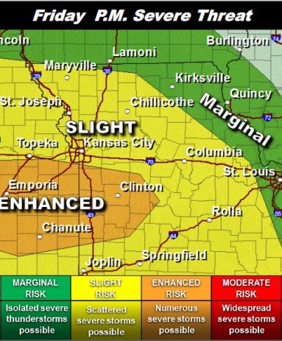
The National Weather Service said the risk for strong to severe thunderstorms is in the forecast for Friday afternoon through the evening.

Large hail will be the primary threat. There is a small threat for isolated tornadoes mainly within the “enhanced” outlook area, according to the weather service. Wyandotte County is north of that area.

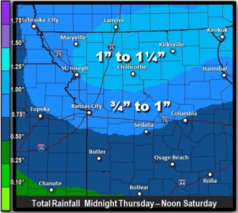
Rainfall in excess of 1 inch with local amounts up to 2 inches in stronger storms is possible, the weather service said.

A warm layer of air aloft known as a “cap” may be difficult to break through and delay the onset or greatly limit the amount of severe weather, according to the weather service.

The first wave of showers and thunderstorms is expected to arrive after midnight tonight, the weather service said. The rain will spread from west to east and exit in the afternoon. The rainfall tied to this first wave will average around a quarter of an inch, according to the weather service.

A second and potentially much stronger round of thunderstorms is expected to form over central Kansas and track northeast along a warm front Friday evening, according to the weather service.

In addition to the threat of severe thunderstorms locally heavy rainfall and minor flooding will define this period, the weather service said. An additional half-inch to 1 inch of rain is likely with local amounts up to 2 inches possible.

For more weather information, visit www.weather.gov.
National Weather Service graphic

National Weather Service graphic

Sunny today, chance of storms Thursday night and Friday

Thunderstorm risk on Friday and Friday night  (National Weather Service graphic)
Thunderstorm risk on Friday and Friday night (National Weather Service graphic)

While today’s forecast is sunny, with a high of 59, there is a risk of thunderstorms starting Thursday night, according to the National Weather Service.

Tonight’s forecast is mostly clear with a low of 39, according to the forecast.

During the daytime Thursday, the high will be 63 with mostly sunny skies, according to the weather service.

Thursday night, there will be a chance of showers and thunderstorms after 1 a.m., the weather service said.

The weather service said the risk for thunderstorms, possibly severe, will increase through the day on Friday and especially Friday evening.

There is a 60 percent chance of storms on Friday and 70 percent on Friday night. Then the risk drops to 30 percent on Saturday.

The weather service said if severe storms form, large hail will be the primary threat. There is a conditional risk for isolated tornadoes, according to the weather service.

If the warm front moves into the region, then there will be a risk for a few tornadoes due to very strong shear near the front, the weather service said.

Since the storm system is two days away, it is likely that the storm map will change, according to the weather service.

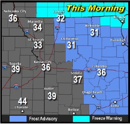
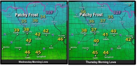
Low temperatures on Thursday morning; frost possible near St. Joseph, Mo. (National Weather Service graphic)

Today’s hit-and-miss thunderstorm weather

National Weather Service graphic

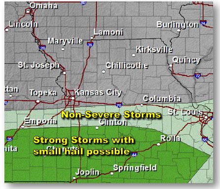
It appears that thunderstorms may hit the general region, but could miss Wyandotte County today.

The National Weather Service’s storm map shows the storms close, but located to the south of Wyandotte County for this afternoon and evening.

Today’s weather in Wyandotte County will be sunny with a high near 66, a west southwest wind 8 to 16 mph with gusts as high as 28 mph. Tonight, it will be partly cloudy with a low around 40, and a west wind of 6 to 13 mph becoming north after midnight.

Wednesday, expect a high of 58 with sunny skies, according to the weather service. Wednesday night’s low will be around 39. There could be some patchy frost in northern Kansas and Missouri on Wednesday and Thursday morning, according to the weather service, although this could be north of Wyandotte County.

The weather service said Thursday will be mostly sunny with a high of 64 and a southeast wind of 3 to 8 mph. Thursday night’s low will be 49.

Next chance for storms is Friday afternoon through Friday night, but there is a question about whether they will be severe, the weather service said.

The high will be near 63, and the chance of showers and thunderstorms is 60 percent mainly after 1 p.m. Friday, according to the weather service.

National Weather Service graphic