The Missouri and Kansas rivers in Wyandotte County are expected to reach their high points on Saturday, according to National Weather Service forecasts.
The rivers are scheduled to decline slightly in the next several days, according to hydrology charts. Kansas City, Kansas, is at the confluence of the Missouri and Kansas rivers.
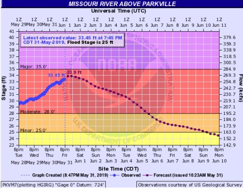
The Missouri River at Parkville was in moderate flood stage at 33.45 feet on Friday night, where flood stage is 25 feet, according to the weather service.
It is projected to fall below flood stage on Monday morning, according to forecasters, although the flood warning will stay in effect through June 11. This gauge is on I-435 between Wyandotte and Platte counties.
The Kansas River at 23rd Street was in minor flood stage Friday night at 38.73 feet, according to hydrology charts. The flood stage is 33 feet. The river should begin falling on Saturday evening, according to forecasters. The gauge is near Kansas Avenue and the Kansas-Missouri state line.
The Missouri River at Kansas City, where the gauge is near U.S. 169 and the Missouri River in Kansas City, Missouri, was at 33.47 feet on Friday night, where flood stage is 32 feet. The river is in moderate flood stage. Major flood stage is 35 feet. The river will continue rising until Saturday morning, then it will fall below flood stage on Wednesday night, according to forecasters.
During a Corps of Engineers news conference on Friday, a National Weather Service meteorologist said although there is some rain in the forecast during the next five days, it is spotty in locations and there are no significant systems producing heavy rainfall.
On June 6-7, the weather service expects heavier rainfall to move into Kansas and Missouri, and it appears at this time the area could receive about an inch of rain, he said. It is too far in advance to be certain of the forecast, however.
Water releases are being increased from the Gavins Point dam in South Dakota, according to Corps officials.
Currently at 70,000 cubic feet per second, the releases from Gavins Point are scheduled to be increased to 75,000 cfs on Saturday morning, officials said. That amount will continue for the next several days.
In Kansas, with similar situations as the reservoirs fill up, Lake Perry is currently releasing 10,000 cfs into the Kansas River, and Tuttle Creek near Manhattan, Kansas, is releasing 30,000 cfs beginning Friday, according to officials. The Kansas reservoirs have a goal of releasing 20 percent of their water to restore flood control pool capacity, according to officials.
To see more information about the rivers, visit https://water.weather.gov/ahps2/index.php?wfo=eax.