
Cool, sunny and windy weather ahead today

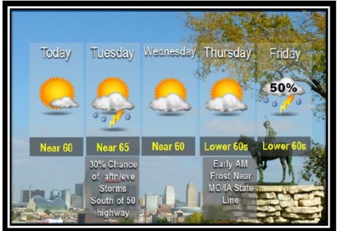
National Weather Service graphic

Today’s forecast is sunny, with a high near 60, and winds 17 to 21 mph, gusting to 32 mph, according to the National Weather Service.

All week long, residents should expect temperatures to be slightly below average, the weather service said.

Even though the relative humidity may drop into the 25 to 30 percent range this afternoon while northwest winds ramp up to about 20 mph, the damp ground and greening native grasses should keep the fire danger below a critical level today, according to the weather service.

Tonight’s low will be around 40, with a southwest wind of 7 to 15 mph, gusting to 21 mph, according to the weather service.

Tuesday, the high will be 66 with mostly sunny skies and a northwest wind of 7 to 10 mph, the weather service said. Tuesday night, the low will be around 43 with calmer winds.

Wednesday, expect a high near 60 with partly sunny skies and a northeast wind of 8 to 13 mph, according to the weather service. Wednesday night, the low will be around 42.

Thursday, the high is near 64, with mostly sunny skies, the weather service said. Thursday night’s low will be around 47.

The weather service said there is a good chance for organized thunderstorms Friday and Friday night. It’s too early to speculate how strong these storms could become but the storm system will bear watching, according to forecasters.

The chance of precipitation on Friday is 50 percent, according to the weather service, and the high will be near 63. Friday night, there is a 60 percent chance of precipitation, with a low of 46.

Saturday, the high will be near 61, with a 30 percent chance of precipitation, the weather service said.

Forecast: Expect some rain today

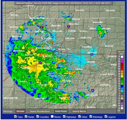
National Weather Service graphic

Scattered storms are in today’s forecast, according to the National Weather Service.

A wide area of rain was moving toward Wyandotte County at 9 a.m. Saturday.

There is an 80 percent chance of precipitation today. The highest chance for precipitation will be from this morning through late afternoon, the weather service said.

Small hail or gusty winds are possible with some of these storms, but widespread severe weather is not expected, according to the weather service.

Today’s high will be near 69 degrees.

Tonight, there is a 50 percent chance of rain, the weather service said, with a low of 56.

An additional round of storms is possible Sunday across the area, the weather service said. At this time, strong to severe storms are not anticipated.

For more weather information today, visit www.weather.gov.

A National Weather Service radar map showed rain and storms moving toward Wyandotte County around 9 a.m. Saturday. (National Weather Service graphic)

Rain falling in Wyandotte County

Rain was falling at 5:10 p.m. Friday in parts of Wyandotte County.

The National Weather Service has a 60 percent chance of thunderstorms in tonight’s forecast, with a low around 60.

The temperature at 5 p.m. was about 78 degrees.

The chance of rain continues Saturday, with 80 percent chance; Saturday night, 60 percent; and Sunday 70 percent.

For more information visit www.weather.gov.