
Bitterly cold temperatures in today’s forecast

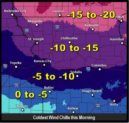
Wind chill readings for Wednesday. (National Weather Service graphic)

Bitterly cold temperatures will greet residents this morning.

The temperature was 15 degrees at 7 a.m., with a wind chill of 4 degrees, according to the National Weather Service.

Today’s high will be near 18 degrees, according to the weather service.

Tonight, the low will be around 2, the weather service said.

Some light snow is possible after 11 a.m. Thursday, through Thursday night, with less than an inch expected, according to the weather service. The chance of precipitation is 20 percent.

Thursday’s high will be near 22, while the wind chill will be between minus 4 and 6, the weather service said.

Forecasters say Friday’s high will be near 36. Friday night, there will be a 30 percent chance of rain before midnight, then a chance of rain, snow, freezing rain and sleet. The low will be 27.

Saturday, there is a 40 percent chance of snow, freezing rain and sleet, with a high near 35, the weather service said.

Saturday night, the forecast is a 30 percent chance of snow, with a low of 14.

Sunday, there will be a high near 22, the weather service said. Sunday night, the low will be around 7, according to the weather service.
Another chance for snow later today

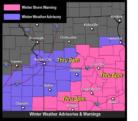
A winter weather advisory is in effect until 10 a.m. Tuesday, Feb. 17, according to the National Weather Service.

Snow fell in parts of the Greater Kansas City area this morning, and precipitation now is reduced as storm clouds have moved past Wyandotte County.

There is another chance for snow this evening, possibly during the mid-to-late afternoon and rush hour, according to the weather service.

This afternoon and evening, the accumulation may be on the light side, only reaching up to about an inch or less, according to the weather service.

Temperatures are expected to drop into the single digits tonight with wind chills falling below zero, the weather service said.

With the low temperatures, any amount of snow on road surfaces could create hazardous and slick driving conditions, according to the weather service. Visibility could be reduced for brief periods, also.

Motorists should be aware of changing conditions if traveling this afternoon and evening, according to the weather service, and allow for extra driving time to get to their destinations.

Looking ahead, Wednesday’s forecast is a high near 16 and mostly sunny skies. The wind chill will be between minus 6 and 4. There will be a north northwest wind of 7 to 14 mph with gusts as high as 20 mph.

Wednesday night, the low will be around 3, the weather service said. A north northwest wind of 6 mph will become calm in the evening, according to the weather service.

Thursday, it will warm up to a high near 24, according to the weather service. Thursday night, the low will be 15.

Friday, the high will be near 36, while Saturday, a 30 percent chance of snow returns to the forecast, with a high of 36.

Area receives inch or two of snow

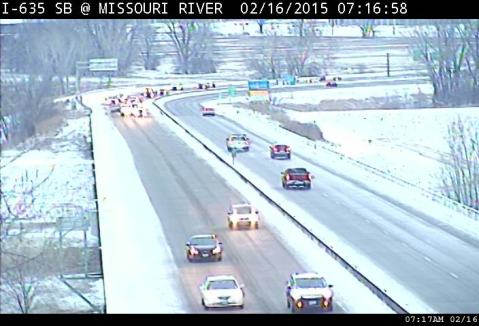
Workers made their way to Wyandotte County on Monday, Feb. 16. This is I-635 at the Missouri River Bridge. (KC Scout photo)

Wyandotte County received an inch or two of snow on Sunday night and early Monday morning.

The National Weather Service advised drivers this morning to be prepared for slippery roads and limited visibilities, and use caution while driving.

An accident was reported about 7:50 a.m. on I-670 eastbound past 7th Street Trafficway, according to KC Scout.

A storm system continues to drop snow to the south of Wyandotte County, and the winter weather advisory will end at 9 a.m.

The temperature at 7 a.m. was 14 degrees, a wind chill reading of 5. Today’s forecast calls for a high near 25, and tonight’s low will be around 19.

Tuesday, there is a slight chance of flurries in the forecast, with a high near 25. Tuesday night, look for a low of 9.

Wednesday’s high will be near 17, with winds of 9 to 14 mph gusting to 20 mph. Wednesday night’s low will be around 5.

Thursday’s high will be 23; Friday, near 34.

On Saturday, there is a 30 percent chance of rain and snow, with a high near 37.

Sunday’s high will be near 29.

National Weather Service graphic