
Rain may continue tonight

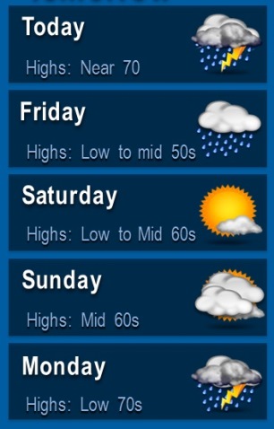
Kansas City area forecast. (National Weather Service graphic)

Heavy rains fell this morning in Wyandotte County and the region, but there is another chance of thunderstorms tonight and Friday, according to the National Weather Service.

Today it will be cloudy as a cold front moves across the area, and temperatures warm up to 70 degrees this afternoon, the weather service said.

There will be a north northeast wind of around 9 percent, with a 40 percent chance of rain today, according to the weather service.

Tonight, there is a 50 percent chance of showers and thunderstorms, the weather service said. The low will be around 45. There will be a northeast wind of 7 to 16 mph, with gusts up to 24 mph.

Friday, expect a 30 percent chance of showers before 1 p.m., the weather service said. The day will be partly sunny with a high near 54. The north northwest wind will be 14 to 22 mph, with gusts as high as 30 mph. Friday night’s low will be 33.

Dry weather will return both Saturday and Sunday as high pressure settles across the region, with showers and storms returning on Monday as the next storm system impacts the region, the weather service said.

Saturday’s high will be near 63, and there will be sunny skies, the weather service said. Saturday night’s low will be 44.

For Easter Sunday, expect mostly sunny skies with a high near 65, according to the weather service. Sunday night, there is a 30 percent chance of showers and thunderstorms, with a low around 49.

Monday, there will be a 30 percent chance of showers and thunderstorms with a high near 72, the weather service said.

Monday night, there is a 50 percent chance of rain with a low of 55, according to the weather service.

Temperatures may reach 80 today; rain in forecast for Thursday

Wednesday afternoon wind gusts. (National Weather Service graphic)

Wednesday will see a beautiful, windy, mostly sunny day with a high near 80 degrees, but look for that to change on Thursday.

Today, a south wind of 13 to 18 mph will increase to 19 to 24 mph in the afternoon, and winds could gust as high as 34 mph, the National Weather Service said.

The windy and dry conditions this afternoon means there is an increased chance of fire danger, the weather service said.

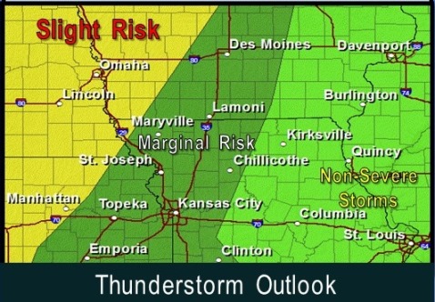
A cold front that will visit Nebraska and Iowa this afternoon, causing thunderstorms, will then move into this region tonight, bringing a small risk for hail and strong winds, according to the weather service. There could be some locally heavy rainfall late tonight and early Thursday morning.

After 1 a.m., there is a 90 percent chance of precipitation, with showers and thunderstorms likely, the weather service said. The low Wednesday night will be around 60.

Thursday, there is an 80 percent chance of rain, the weather service said. A north northeast wind will be 8 to 13 mph. The high will be near 68. There could be between a tenth and quarter of an inch of rain, the weather service said.

Thursday night, there will be a 40 percent chance of showers. The low will be around 44.

Friday, there will be a 30 percent chance of showers before 1 p.m., the weather service said. Skies will be partly sunny with a high near 54. The north wind will be 16 to 20 mph, with gusts as high as 28 mph.

Friday night, the low will be around 33.

Saturday, skies will be sunny with a high near 64, the weather service said. Saturday night’s low will be around 44, according to the weather service.

Sunday, the high will be near 67, and Sunday night, the low around 49, the weather service said.

On Monday, there will be a 30 percent chance of showers and thunderstorms, with a high near 70, according to the weather service. Monday night, the low will be around 56.

Tuesday’s high will be near 71, the weather service said.

Thunderstorm outlook. (National Weather Service graphic)

Rain in the forecast through Thursday. (National Weather Service graphic)

Temperatures today in 70s; outdoor fire danger increases

Today’s forecast is sunny with a high near 76, according to the National Weather Service.

The weather service also warned residents that there is an elevated fire danger this afternoon.

While temperatures rise into the 70s, relative humidity will drop to slightly below 25 percent, the weather service said. This warm and very dry air will combine with northeast winds around 8 mph to yield a slightly increased risk for wildfires this afternoon, the weather service stated.

Tonight’s low will be 53, and Wednesday’s high will be near 81, the weather service said.

Thunderstorms are back in the forecast for Wednesday night through Saturday, according to the weather service. At this time they appear to be non-severe, but a few strong storms with large hail and gusty winds cannot be completely ruled out in the region, according to the weather service.