Storms moved through the metropolitan Kansas City area this morning, bringing a cool front with them.
Temperatures were 69 degrees at 7 a.m., and will fall to about 61 by 5 p.m., the National Weather Service said.
While there is still a chance of showers before 1 p.m. today, it appears that most of the storms have already moved through the area, according to the weather service.
Tonight, the low will be around 38, with a west wind of 15 to 20 mph, decreasing to 8 to 13 mph after midnight, the weather service said. Winds could gust as high as 29 mph.
Friday, expect a high near 66, with a west wind of 7 to 11 mph, according to the weather service. Friday night, there will be a low around 44, with a west northwest wind around 6 mph.
On Saturday, expect mostly sunny skies with a high near 70, the weather service said.
For more weather information, visit www.weather.gov.
With rain and hail falling in parts of Wyandotte County at 5:15 p.m., the National Weather Service has the area under a weather advisory for storms.
There also is a flash flood watch in effect in Wyandotte County from 4 p.m. April 8 through 10 a.m. April 9, according to the weather service.
Strong to severe storms may develop this afternoon and tonight. With these storms, it is possible to have very large hail, damaging winds and tornadoes in some areas.
For more weather information, visit www.weather.gov.
National Weather Service graphic
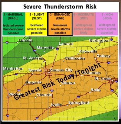
Severe weather will be possible today and tonight across much of the area, according to the National Weather Service.
There is a dense fog advisory now in effect until 11 a.m. on Wednesday in the region, weather service said.
Residents are advised to slow down, use their headlights, and leave plenty of distance ahead of them in the fog.
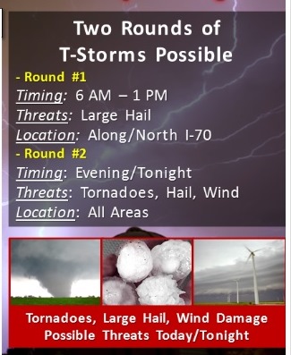
Strong storms are possible this morning with large hail threatening, the weather service said. Most of the morning risk has already left the area.
Another round of severe storms is expected this afternoon, after 5 p.m., with a threat for large hail, damaging winds and isolated tornadoes, especially for areas along and south of a line from the northern Kansas City metro area to Kirksville, Mo., according to the weather service.
Additional strong to severe storms are possible early Thursday afternoon, the weather service said.
Today’s high will be near 78. An east wind of 7 to 15 mph will become south in the afternoon, according to the weather service. Winds could gust as high as 22 mph. The chance of rain is 60 percent. Between a quarter and half-inch is possible, the weather service said.
Tonight, showers and thunderstorms are possible mainly before 1 a.m. The low will be 62, with a south wind of 14 to 17 mph and gusts as high as 26 mph, according to the weather service. The chance of rain is 80 percent.
On Thursday, there is a chance of showers and thunderstorms before 1 p.m., then a slight chance of showers, according to the weather service. The high will be near 69. A south southwest wind of 13 to 18 mph will become west northwest in the afternoon, the weather service said, with wind gusts of up to 28 mph. The chance of rain is 40 percent. National Weather Service graphic