
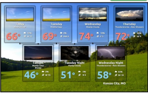
Dry weather ahead Monday and Tuesday

National Weather Service graphic

High pressure returns to the region today, and dry weather is expected through Wednesday, according to the National Weather Service.

Today’s forecast is sunny with a high near 63. There will be a west wind of 9 to 17 mph, with gusts as high as 26 mph, the weather service said.

Tonight, it will be mostly clear with a low around 44, according to the weather service.

Tuesday, expect sunny skies, with a high near 68, according to the weather service. The wind will be west northwest from 5 to 7 mph becoming north northeast on Tuesday afternoon. Tuesday night’s low will be around 50, with mostly clear skies.

The Kansas City area is still a little bit short compared to the average precipitation this year, according to the weather service.

Showers and storms will return to the area Wednesday night and Thursday, the weather service said. There is a 70 percent chance of rain Wednesday night and a 60 percent chance Thursday.

It remains too early to know whether this activity will be severe or not, forecasters said.
Weather service issues thunderstorm watch through 10 p.m. today

Thunderstorms have moved through Wyandotte County during the past two hours, the rain has stopped, and the National Weather Service at 1:45 p.m. has issued a thunderstorm watch effective until 10 p.m. Sunday.

The weather service radar map shows a line of thunderstorms has finished moving through Wyandotte County. The radar map shows some thunderstorms currently in the Topeka, Kan., area that might possibly be moving toward Wyandotte County this afternoon.

For more weather information, visit www.weather.gov.

Rainy Mother’s Day weather ahead

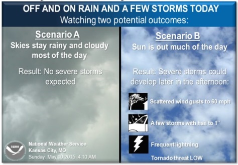
National Weather Service graphic

It was raining as of noon today in Kansas City, Kan., with the sound of thunder reverberating through the area.

Severe thunderstorms will be possible today but not likely, according to the National Weather Service forecast.

Showers and thunderstorms developing across southern Kansas and further southward into central Oklahoma and Texas are expected to stream northeastward this morning and arrive over the local area by late morning or early afternoon, the weather service said.

This will keep the area stable and not allow severe storms to develop. If the area does happen to break out in sun for a period this afternoon then the possibility for severe storms will increase for late afternoon-evening with damaging winds and large hail the main threats, according to the weather service.

However, at this time, severe weather looks unlikely, the weather service said.

Today’s high will be near 74, with a south wind of 11 to 14 mph and gusts as high as 20 mph today.

Tonight, there is a 50 percent chance of rain and thunderstorms before midnight. The low will e around 48. A south wind of 9 to 14 mph will become west after midnight, and winds could gust as high as 18 mph, the weather service said.

Monday’s weather will be sunny with a high near 64, a west wind of 10 to 15 mph and gusts as high as 21 mph.

For weather updates, visit www.weather.gov.