
Accident reported on southbound I-635 near State
Serving Kansas City (Wyandotte County) Kansas for over 50 years!
A single-vehicle fatality accident in the 1800 block of State Avenue overnight is under investigation.
Kansas City, Kansas, police officers responded to the accident around 12:15 a.m. Saturday, according to a police spokesman.
When they arrived, they found a single vehicle had wrecked into a house, the spokesman stated.
The driver was extricated from the vehicle and taken to a hospital in serious condition. A passenger was ejected from the car and pronounced dead at the scene.
A preliminary investigation revealed the vehicle was westbound on State Avenue at a high rate of speed when it lost control and left the roadway, the spokesman stated.
Detectives with the police department are currently investigating the fatality. Anyone with information on this case is urged to call the TIPS hotline at 816-474-TIPS, the spokesman stated.


The new year arrived in Wyandotte County with an icy storm.
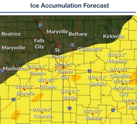
A wintry mix and sleet and some freezing rain are covering roads and lawns on Saturday morning, New Year’s Day.
The transition to all snow is expected by noon, the National Weather Service said.
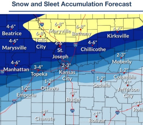
Up to a half-inch of sleet is possible along the I-70 corridor, including Wyandotte County, according to the weather service.
The highest snow rates will occur during the daylight hours today, according to the weather service. Accumulating snow will end by the late evening.
Wyandotte County is under a winter weather advisory until midnight tonight.
A wind chill advisory has been issued for Wyandotte County and the entire area from midnight tonight until 10 a.m. Sunday, Jan. 2, according to the weather service. There are dangerous wind chills.
Temperatures were at 17 degrees with a wind chill of 4 at 9 a.m. Saturday, the weather service said. There was light snow, fog and mist in the area.
Temperatures will remain below freezing through Monday afternoon, according to the weather service. Wind chill values tonight into Sunday morning will range from minus 10 to minus 23, the weather service said.
Residents should plan on slippery road conditions, according to the weather service. Cold wind chills could result in hypothermia if precautions are not taken.
Motorists are advised to slow down and use caution while traveling, the weather service said. There may be sleet or ice on the roads. Wear appropriate clothing while outdoors or while traveling. For road conditions, call 5-1-1.
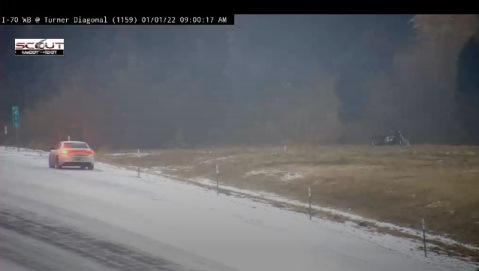
KC Scout reported accidents on area highways, including one on the Turner Diagonal at 8:32 a.m. Saturday.
As of 9:04 a.m. Saturday, the Board of Public Utilities’ outage map was reporting about 68 total customers without power, near 78th and I-70.
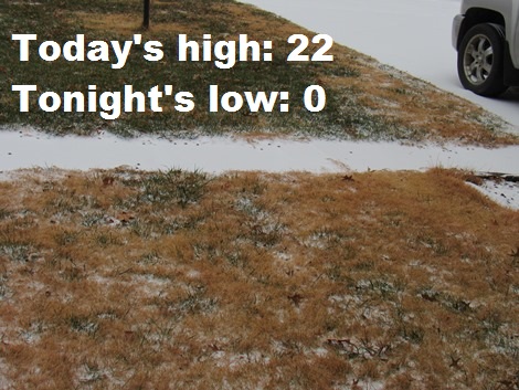
Today, New Year’s Day, there is a 100 percent chance of snow, possibly mixed with sleet, becoming all snow after noon, the weather service said. Patchy blowing snow is in the forecast between noon and 2 p.m. The temperature may fall to around 10 degrees by 5 p.m. The wind chill will be between minus 8 and 2. A north wind of 16 to 18 mph will become southeast in the afternoon. Winds may gust as high as 29 mph. A total daytime accumulation of snow and sleet of 1 to 3 inches is possible.
Tonight, there is a 40 percent chance of snow, mainly before midnight, according to the weather service. It will be cloudy during the early evening, then gradually clearing, with a low of 0. Wind chill values are between minus 7 and minus 14. A south wind of 10 to 17 mph will become north in the evening. Winds may gust as high as 25 mph.
Sunday, it will be sunny and cold, with a high near 15, the weather service said. Wind chill will be between minus 5 and minus 15. A north northwest wind of 5 to 10 mph will become light and variable in the afternoon.
Sunday night, it will be mostly clear, with a low of 5, according to the weather service. A calm wind will become south southwest around 5 mph after midnight.
Monday, it will be sunny, with a high near 37 and a south southwest wind of 6 to 11 mph, gusting as high as 20 mph, the weather service said.