A victim stated a suspect shot the victim for an unknown reason at 8:30 a.m. June 8 in the 1800 block of North 26th Street, according to a social media post by the Kansas City Kansas, Police Department.
The victim had non-life-threatening injuries, according to the report.
Indecent liberties reported
Indecent liberties were reported at 1:49 a.m. June 8, according to a social media post by the Kansas City, Kansas, Police Department.
Ramp and lane closures are scheduled Tuesday in Wyandotte County, according to the Kansas Department of Transportation.
Traffic on these projects will be diverted using mobile lane closures, signs and traffic cones, according to a KDOT spokesman.
For pothole patching, closures on Tuesday include:
• Alternating lane closures on northbound and southbound I-435, from the Kansas River to Parallel Parkway, from 9 a.m. to 3 p.m., Tuesday, June 9.
For grading work, the closures include:
The following ramps will close from 8 a.m. to 4 p.m., Tuesday, June 9. • Southbound Turner Diagonal to westbound I-70, • Eastbound I-70 to southbound Turner Diagonal.
For pipe maintenance work, the closures include:
• Left lane closure on southbound I-635 from State Avenue to I-70, from 7 a.m. to 4 p.m., Tuesday, June 9 to Friday, June 12.
The girders for the Lewis and Clark Viaduct project will be unloaded and installed on Wednesday, June 10, and Friday, June 12. Because of shipping delays, the girders did not arrive in time for the project, earlier this week.
For new bridge girder unloading, closures include:
Intermittent lane and ramp closures on eastbound I-70 to unload new bridge girders onto a trestle in the Missouri River as part of the Lewis and Clark Viaduct Bridge project. Each I-70 closure could last for approximately 15-20 minutes. Work will occur on Wednesday, June 10, and Friday, June 12.
Two girders will be placed each day from approximately 1:30 p.m. to 4:30 p.m., weather permitting. Traffic will be stopped on eastbound I-70 and several on-ramps to unload each girder. The following ramps will be temporarily closed; Fairfax Trafficway to eastbound I-70, Washington Boulevard, Minnesota Avenue and eastbound I-70.
Traffic will be controlled using construction trucks and digital message boards. An additional two days will be scheduled to finish unloading bridge girders, at a later date. Travelers should expect delays and find alternative routes.
A KDOT spokesman urged all motorists to be alert and obey the warning signs when approaching and driving through a highway work zone. To stay aware of all road construction projects across Kansas go to www.kandrive.org or call 5-1-1. Motorists are urged to drive safely and always wear their seat belts, according to the spokesman.
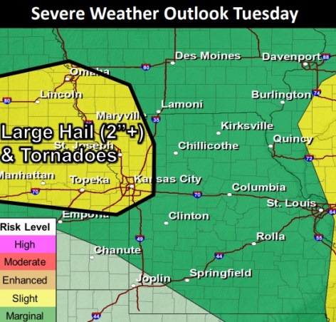
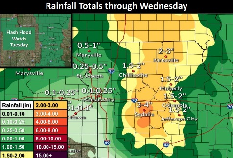
Wyandotte County is in an area that has a slight chance of severe weather on Tuesday afternoon. High wind gusts and hail are possible on Tuesday afternoon and evening. Tornadoes are possible between 4 p.m. and 9 p.m. (National Weather Service graphic)Wyandotte County could receive from a tenth to a quarter-inch of rain with these storms Tuesday and Wednesday. (National Weather Service graphic)
Remnants of tropical storm Cristobal will be moving through the region, according to the National Weather Service forecast.
In Wyandotte County, showers and thunderstorms are likely today, with severe weather possible after 4 p.m. and also overnight, the weather service said.
Rainfall here may total a tenth to a quarter of an inch, while heavy rains are possible over central Missouri, where flash flooding and river flooding will be possible, according to the weather service.
Severe weather is possible in Wyandotte County and the surrounding area after 4 p.m. Tuesday, the weather service said.
On Wednesday, strong wind gusts of 45 mph are possible from 1 a.m. to noon, and a wind advisory has been issued for Wednesday, according to the weather service.
Today, there is a 60 percent chance of showers, with thunderstorms possible after 4 p.m., the weather service said. The high will be near 88, with a light and variable wind becoming southeast 5 to 9 mph in the morning. New rainfall amounts of less than a tenth of an inch are possible.
Tonight, there is a 60 percent chance of showers and thunderstorms, then showers likely after 1 a.m., according to the weather service. The low will be around 57 with a southwest wind of 16 to 21 mph becoming west northwest 7 to 12 mph after midnight. Winds could gust as high as 46 mph. Less than a tenth of an inch is of rain is possible.
Wednesday, there is a 60 percent chance of showers, mainly before 7 a.m., the weather service said. The high will be near 76 with a northwest wind of 23 to 28 mph, decreasing to 17 to 22 mph in the afternoon. Winds may gust as high as 49 mph. Less than a tenth of an inch of rain is possible.
Wednesday night, it will be clear, with a low of 58, according to the weather service. A west northwest wind of 5 to 9 mph will become calm in the evening. Winds may gust as high as 20 mph.
Thursday, it will be sunny with a high near 85, the weather service said. A calm wind will become west southwest 5 to 7 mph in the morning. Winds could gust as high as 18 mph.
Thursday night, it will be mostly clear, with a low of 62, according to the weather service.
Friday, it will be sunny, with a high near 86, the weather service said.
Friday night, it will be clear, with a low of 63, according to the weather service.
Saturday, it will be sunny, with a high near 85, the weather service said.
Saturday night, it will be mostly clear, with a low of 63, according to the weather service.
Sunday, it will be mostly sunny, with a high near 85, the weather service said.
Sunday night, it will be partly cloudy, with a low of 66, according to the weather service.
Monday, it will be mostly sunny, with a high near 88, the weather service said.
For more weather information, visit www.weather.gov.