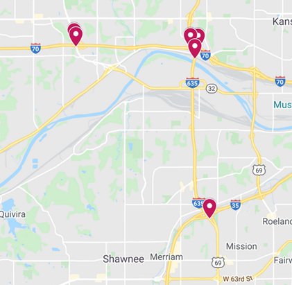
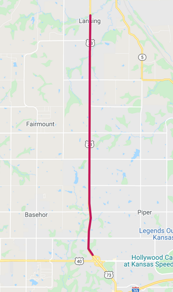
Ramp and lane closures are scheduled in Wyandotte County. (KDOT map)U.S. 73 has lane closures scheduled through Saturday for pavement overlay. (KDOT map)
Ramp and lane closures are scheduled in Wyandotte County now through June 27, according to the Kansas Department of Transportation.
Traffic on the projects will be diverted using mobile lane closures, signs and traffic cones.
For bridge joint inspection, closures include:
• Alternating ramp closures, eastbound and westbound I-70 to southbound I-635, from 9 a.m. to 3 p.m., Monday, June 22. • Alternating lane closures, southbound I-635 from I-70 to Kansas Avenue, from 9 a.m. to 3 p.m., Monday, June 22.
For grading work, the closures include: • The following ramps will close from 8 a.m. to 3 p.m., Monday, June 22, to Friday, June 26 and from 7 a.m. to 4 p.m., Saturday, June 27. • Southbound Turner Diagonal to westbound I-70, • Eastbound I-70 to southbound Turner Diagonal.
For pavement overlay, closures include: • One lane closed, northbound and southbound U.S. 73 from State Avenue in Kansas City, Kansas, to Ida Street in Lansing, from 6:30 p.m. to 6 a.m., Monday, June 22, to Friday, June 26, and all day on Saturday, June 27.
A KDOT spokesman urged all motorists to be alert and obey the warning signs when approaching and driving through a highway work zone. To stay aware of all road construction projects across Kansas go to www.kandrive.org or call 5-1-1. The spokesman urged motorists to drive safely and always wear their seat belts.
Two Unified Government committees will meet at 5 p.m. Monday, June 22, in a remote Internet meeting.
The Public Works and Safety Committee meeting will meet at 5 p.m.
On the agenda:
• A $1 million grant for the Kansas City, Kansas, Police Department, in conjunction with the Health Department, on community-based crime reduction.
• A resolution recommending the naming of a 7-mile tributary in Wyandotte County after Chief Ne Con He Con, who lived from 1809 to 1863. He was the chief of the Wolf Band of the Delaware Tribe and is buried near the headwaters of an unnamed tributary of Wolf Creek. Ne con He con Creek was the historical name of the tributary. The U.S. Board on Geographic Names has received a proposal from the vice president of the Bonner Springs Historic Preservation Society to make Ne con He con Creek the official name. They have asked the Unified Government for their input.
• Also on the Public Works and Safety Committee is an update on the KC Levee projects, including the Argentine, Armourdale and Central Industrial District units.The UG has joined with the U.S. Army Corps of Engineers, Kaw Valley Drainage District and Kansas City, Missouri, in a $435 million KC Levees Project. The design of the 17-mile levee upgrades on Argentine, Armourdale and CID Levee units is taking place and real estate acquisition has begun, according to the agenda.
The Administration and Human Services Committee will meet after the Public Works and Safety Committee meeting.
On the agenda for the Administration and Human Services Committee will be:
• A proposal to rename the UG Urban Planning and Land Use Department to the Planning and Urban Design Department.
• An update on Parks and Recreation Department software.
• A discussion about the Community Development Department Revised 2020 and Proposed 2021 budgets, and the Draft 2020-2021 Annual Action Plan.
• A request to accept grant funds of $750,000 from the Metro Rapid Response Fund for the UG Health Department’s COVID response.
The agendas are online at www.wycokck.org.
To view the meetings, see cable channel 2 on Spectrum or channel 141 on Google TV. It also is on YouTube.
The meeting will be on Zoom at https://zoom.us/j/96881223765?pwd=SXR2RnR3L3BIOUQvTjZWM3VtcXZ0Zz09 Password: 799603
Or iPhone one-tap : US: +13462487799,,96881223765# or +16699009128,,96881223765# Or telephone: Dial (for higher quality, dial a number based on your current location): US: +1 346 248 7799 or +1 669 900 9128 or +1 253 215 8782 or +1 301 715 8592 or +1 312 626 6799 or +1 646 558 8656 or 888 475 4499 (Toll Free) or 877 853 5257 (Toll Free) Webinar ID: 968 8122 3765 International numbers available: https://zoom.us/u/atZUpG904 Or an H.323/SIP room system: H.323: 162.255.37.11 (US West) 162.255.36.11 (US East) 115.114.131.7 (India Mumbai) 115.114.115.7 (India Hyderabad) 213.19.144.110 (EMEA) 103.122.166.55 (Australia) 209.9.211.110 (Hong Kong SAR) 64.211.144.160 (Brazil) 69.174.57.160 (Canada) 207.226.132.110 (Japan) Meeting ID: 968 8122 3765 Password: 799603 SIP: [email protected] Password: 799603
There is a 30 percent chance of thunderstorms and rain today, according to the National Weather Service. (National Weather Service graphic)
A 30 percent chance of thunderstorms and rain is in the forecast today, according to the National Weather Service.
This morning, some showers were moving north of the Wyandotte County area. Storms are more likely in the afternoon, the weather service said.
Strong winds, small hail, locally heavy rainfall and lightning are the primary threats of storms today, according to the weather service. A cold front will move through the area today, shifting winds to the north with gusts in the 10 to 20 mph range.
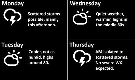
Isolated to scattered storms are possible again late Wednesday night into Thursday morning, the weather service said. No severe weather is expected at this time.
Several rounds of thunderstorms are possible Friday through Sunday, according to the weather service. The threat of severe weather is low at this time.
Today, there is a 30 percent chance of showers and thunderstorms, with a high near 83, the weather service said. A southwest wind of 5 to 10 mph will become north northwest in the afternoon. Less than a tenth of an inch of rain is in the forecast.
Tonight, there is a 20 percent chance of showers and thunderstorms before 7 p.m., then a slight chance of showers between 7 p.m. and 10 p.m., according to the weather service. The low will be around 63 with a north northwest wind of 5 to 9 mph.
Tuesday night, the low will be around 62 with a north northwest wind of 6 mph, becoming calm in the evening, according to the weather service.
Wednesday, it will be mostly sunny, with a high near 85 and a calm wind, the weather service said.
Wednesday night, there is a 40 percent chance of showers, then a chance of showers and thunderstorms after 1 a.m., according to the weather service. The low will be around 67. Less than a tenth of an inch is in the forecast.
Thursday, it will be mostly sunny with a high near 88, the weather service said.
Thursday night, it will be partly cloudy, with a low of 74, according to the weather service.
Friday, there is a 40 percent chance of showers and thunderstorms, after 1 p.m., with a high near 90, the weather service said.
Friday night, there is a 50 percent chance of showers and thunderstorms, with a low of 72, according to the weather service.
Saturday, there is a 40 percent chance of showers and thunderstorms, with a high near 88, the weather service said.
Saturday night, there is a 30 percent chance of showers and thunderstorms, with a low of 74, according to the weather service.
Sunday, there is a 30 percent chance of showers and thunderstorms, with a high near 90, the weather service said.