Kansas City, Kan., Public Schools
Tuesday, Sept. 8
Cheese pizza, corn, garden salad, peaches and milk.
Alternate entrees available including chef’s salad, fruit salad, yogurt muffin basket and vegetarian options.
Bonner Springs-Edwardsville Public Schools
Nachos; pizza quesadilla, garden salad, southwest beans, fruit, pineapple; taco salad, southwest beans, fruit, pineapple and cornbread.
All menus from all districts subject to change.
The Kansas City T-Bones scored five first inning runs, but Gary scored five eighth inning runs to stun Kansas City 9-7 Monday afternoon at the U.S. Steelyard in Gary, Ind.
Kansas City roared out of the gate with five first inning runs, capped by a three-run home run by Kyle Robinson, to jumpstart a 5-0 lead.
The T-Bones added another run in the third inning with Adam Bailey’s 17th home run of the season, giving Kansas City a 6-2 lead. Sergio Leon added an RBI single in the fifth inning, which plated Bailey, and Kansas City held a 7-4 lead.
The Railcats, down 7-4 in the bottom of the eighth inning, erupted with five runs against Kansas City reliever Aaron Baker (4-5) to take a late 9-7 lead. The big blow was a one-out grand slam home run by Adam Taylor with one out in the inning.
Kansas City added two hits in the ninth inning, but failed to tie the game. The loss ends Kansas City’s season one game below .500, with a final record of 49-50.
Kansas City started the season 1-10, and the T-Bones put together an impressive run in June and July. The T-Bones were in the wild card race up until late last week.
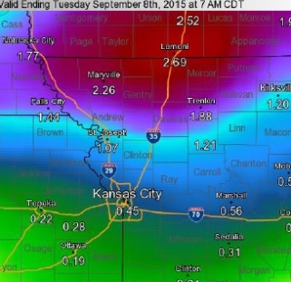
Rain amounts on Labor Day. (National Weather Service graphic)
Several rounds of heavy rain producing thunderstorms will affect the region through Tuesday night.
About an inch and a half of rain had fallen by 10 a.m. Monday. Around an inch or two of rain is expected through Tuesday night in Wyandotte County, according to the National Weather Service.
Northern Missouri has the greatest chance of seeing flooding type rains early this morning and again tonight.
A few isolated severe storms are possible which could produce gusty winds and damaging hail. Wyandotte County has a marginal risk of severe weather tonight and through Tuesday night, according to the weather service.
The showers and thunderstorms will be tied to a slow-moving cold front and outflow boundaries generated by earlier storms, the weather service said.
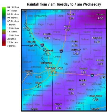
Another round or two of storms will affect the entire region Tuesday and Tuesday night with most areas picking up an inch or more of rain, according to the weather service.
While the primary concern over the next two days will center around the threat of heavy rains and flooding an isolated storm or two could become severe late this afternoon and evening and again Tuesday afternoon and evening, according to the weather service. Marginally severe hail and high winds to 60 mph will be possible.
The rain on Monday, Labor Day is expected to clear out in mid-morning. Then the temperature may reach 89, with a heat index of 95.
Rain has a 70 percent chance of returning tonight, mainly after 10 p.m., according to the weather service.
Tuesday, showers and storms are in the forecast again, with an 80 percent chance of precipitation, the weather service said. Between a half-inch and three-quarters of an inch of rain is possible, the weather service said. The high will be near 83.
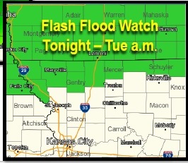
Wednesday’s forecast is dry, mostly sunny, with a high near 81. Flash flood watch (National Weather Service graphic) Rainfall from Tuesday morning to Wednesday morning (National Weather Service graphic)