The National Weather Service has issued a severe thunderstorm watch from 2:45 p.m. Saturday through 10 p.m. Saturday.
Wyandotte County and several other counties are under the severe thunderstorm watch, according to the weather service.
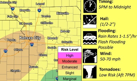
Severe storms are possible this afternoon into tonight across the entire area, the weather service said. Possible severe weather includes damaging winds, large hail and a tornado.
In addition, heavy rain is expected with these storms, which could lead to flash flooding and additional river flooding the weather service said. Residents are advised to avoid flooded roadways, turn around and take another route.
A flash flood watch is in effect from 7 p.m. Saturday through 2 a.m. Monday, according to the weather service.
Storms also are possible on Sunday morning and afternoon, according to the weather service. By Monday, from 2 to 3 inches of rain may fall over the region.
Wyandotte County remains under a flood warning for the Missouri River at Parkville, which affects Wyandotte County, and is currently in minor flood stage, according to the weather service.
For more weather information, visit www.weather.gov.