Following 4.25 inches of rain over two days, Wyandotte County is under a flood warning through 11 a.m. Wednesday, April 27.
The flood warning for urban areas and small streams covers Wyandotte County as well as surrounding counties.
According to the weather service, as of 5 a.m. Wednesday, local law enforcement officials reported a number of roads closed because of high water from torrential rains Tuesday night.
Route DD southwest of Gower, Mo., was closed due to high water; Route B between Edgerton and Ridgely in Missouri was closed in both directions; Route E between Camden Point and Ridgely was closed in both directions; and Route KK between U.S. 69 in Smithville, Mo., and Route B to the west was closed in both directions, the weather service stated.
Residents were advised to turn around and go back if there is water in the roadway.
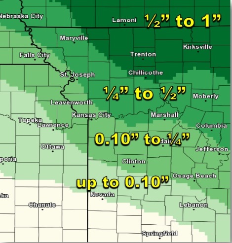
The weather service said between 3 and 5 inches of rain fell in the region since Tuesday morning.
One Wyandotte County location measured 1.75 inches of rain fell in the Tuesday morning rains, plus another 2.5 inches of rain Tuesday night and Wednesday morning, for a total of 4.25 inches of rain.
As of 8 a.m. Wednesday, the Board of Public Utilities’ outage map reported 16 customers without power in Kansas City, Kan., at different locations.
Flooding
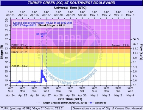
According to the National Weather Service, flooding was occurring at Turkey Creek at Southwest Boulevard at 2 a.m. Wednesday, and was expected to crest at 47 feet. Flooding there was projected to end Friday evening.
Other areas in the region that were flooding, according to the weather service, included:
– Atchison, Kan., projected to flood at 6 a.m. Saturday.
– Easton, Kan., Stranger Creek, Wednesday.
– Tonganoxie, Kan., 10 a.m. Wednesday.
– Sharp’s Station in Missouri, currently flooding.
– Platte City, Mo., currently flooding.
– Mosby, Mo., currently flooding.
– Osawatomie, Kan., Marais de Cygne river, 2 p.m. Wednesday.
– Lawrence, Kan., 2 a.m. Wednesday.
Forecast
Today, residents can expect more rain, with a 40 percent chance of showers and thunderstorms, mainly after 9 a.m., according to the weather service. The high will be near 72, and a south wind of 7 to 14 mph will gust as high as 18 mph.
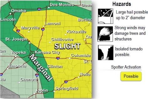
The weather service said severe thunderstorms are possible mainly between 2 p.m. and 10 p.m. today. Primary hazards may include large hail and damaging winds, possible a few tornadoes. Locally heavy rainfall is possible. The weather service is not sure yet how severe the storms may be, a lot depends on how fast air mass will recover from the morning’s storms.
Tonight, there is a 20 percent chance of rain before 10 p.m., with a low of 48, the weather service said.
Thursday will be a break in the rainy weather.
Thursday will be mostly sunny with a high near 67, the weather service said, and a west wind of 8 to 11 mph. Thursday night, the low will be 48.
Friday, there is a 30 percent chance of precipitation with a high of 67, according to the weather service. Friday night, the chance of showers is 70 percent. The low will be 56.
Rain and storms also are in the forecast for Saturday and Sunday, according to the weather service.
For more weather information, visit www.weather.gov or listen to a weather radio.