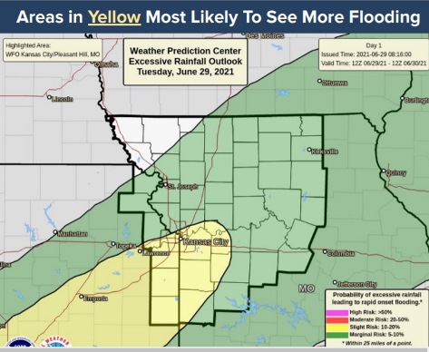
Wyandotte County is under a flash flood watch until 7 p.m. Tuesday, and also under a flood advisory this morning until noon Tuesday, according to the National Weather Service forecast.
Heavy rain was falling in Wyandotte County on Tuesday morning, causing urban and small stream flooding, according to the weather service.
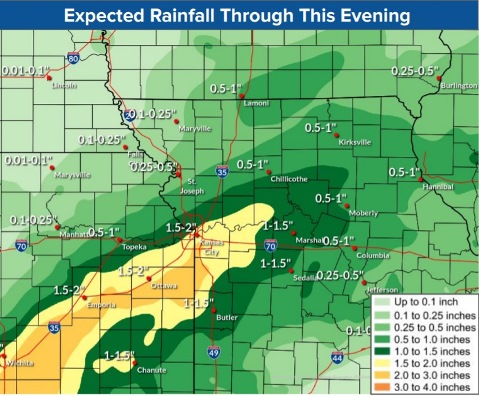
Between a half and 1.5 inches of rain had fallen by 8:53 a.m. Additional amounts of a half-inch to an inch are expected, resulting in minor flooding, the weather service said.
The weather service advised motorists to turn around and take another route when encountering flooded roads.
Scattered showers and storms are moving through the area again on Tuesday. A flash flood watch is in effect through 7 p.m. Tuesday, according to the weather service.
More showers and thunderstorms are expected Wednesday, the weather service said.
According to the weather service, off and on thunderstorms may continue through Tuesday and Wednesday, with the areas most affected south and east of I-35.
At 8:45 a.m. Tuesday, the Missouri and Kansas rivers in Wyandotte County were not in action stage or flood stage, according to hydrology charts from the USGS.
Today, there is an 80 percent chance of precipitation with showers and possibly a thunderstorm, the weather service said. Some of the storms could produce heavy rain. The high will be near 77 with a light and variable wind becoming south southwest around 5 mph. Between a half and three-quarters of an inch of rain is possible.
Tonight, there is a 70 percent chance of showers and likely a thunderstorm before 7 p.m., then a chance of showers nad thunderstorms between 7 p.m. and 1 a.m., then showers likely and possibly a thunderstorm after 1 a.m., according to the weather service. The low will be around 70 with a south wind around 5 mph becoming calm in the evening. Between a tenth and quarter-inch of rain is possible.
Wednesday, there is a 70 percent chance of precipitation, with showers and possibly a thunderstorm, the weather service said. The high will be near 81 with a calm wind becoming south around 5 mph. Between a quarter and half-inch of rain is possible.
Wednesday night, there is a 30 percent chance of showers and thunderstorms, with a low of 69 and a calm wind, according to the weather service. Between a tenth and quarter-inch of rain is possible.
Thursday, there is a 20 percent chance of showers and thunderstorms, with a high near 85, the weather service said. A calm wind will become northeast around 6 mph in the afternoon.
Thursday night, there is a 10 percent chance of showers, with a low of 65, according to the weather service.
Friday, it will be sunny, with a high near 83, the weather service said.
Friday night, it will be mostly clear, with a low of 62, according to the weather service.
Saturday, it will be sunny, with a high near 83, the weather service said.
Saturday night, it will be mostly clear, with a low of 63, according to the weather service.
Sunday, Independence Day, it will be sunny with a high near 86, the weather service said.
Sunday night, it will be mostly clear, with a low of 66, according to the weather service.
Monday, it will be mostly sunny, with a high near 89, the weather service said.
For more weather information, visit www.weather.gov.