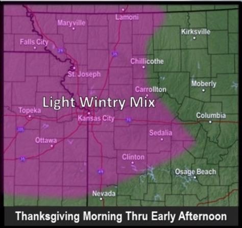
A wintry mix of snow and rain is possible on Thanksgiving morning, according to the National Weather Service.
The precipitation will change to all rain by late morning or early afternoon, the weather service said. Precipitation is expected to start in the south and gradually move north in the afternoon.
Snow accumulation of a half-inch or less, with very little ice accumulation, is possible along and west of I-35, according to the weather service.
While hazardous travel is not expected at this time, there could be a light glaze of ice on the road in some areas, the weather service said.
Freezing drizzle is possible north of Highway 36, which is around the St. Joseph, Missouri, area, after sunset on Thanksgiving, according to the weather service.
Isolated thunderstorms will be possible Friday night, with windy conditions expected again on Sunday, the weather service said.
The wind advisory has been lifted for Wyandotte County this morning, but remains in effect in areas to the east.
The temperature was 35 degrees with a wind chill reading of 26 at 9 a.m. on Wednesday, according to the weather service.
Today, it will be sunny, with a high near 42 and a west northwest wind of 13 to 18 mph, gusting as high as 32 mph, the weather service said.
Tonight, there will be increasing clouds, with a low of 31, according to the weather service. A northwest wind of 6 mph will become east northeast after midnight.
Thanksgiving Day, Thursday, there will be a 70 percent chance of precipitation, the weather service said. There is a chance of snow before 10 a.m., then rain and snow likely between 10 a.m. and 3 p.m., then rain likely after 3 p.m. The high will be near 36 with an east wind of 5 to 8 mph. Less than a half-inch of snow is likely.
Thursday night, there is a 30 percent chance of precipitation, with rain possible after midnight. The low will be around 34 with a calm wind becoming southeast around 5 mph after midnight, according to the weather service.
Friday, there is a 90 percent chance of rain, the weather service said. Rain is likely before noon, then showers are possible between noon at 3 p.m., with showers and possibly a thunderstorm after 3 p.m., the weather service said. The high will be near 51 with a southeast wind of 5 to 7 mph, gusting as high as 18 mph. Between a half and three-quarters of an inch of rain are possible.
Friday night, there is a 90 percent chance of showers and possibly a thunderstorm before midnight, then showers are likely, according to the weather service. The low will be around 46. New precipitation amounts between a half and three-quarters of an inch are possible.
Saturday, it will be mostly sunny, with a high near 59, the weather service said.
Saturday night, it will be partly cloudy, with a low of 35, according to the weather service.
Sunday, it will be mostly cloudy, with a high near 42, the weather service said.
Sunday night, it will be mostly cloudy, with a low of 27, according to the weather service.
Monday, it will be sunny with a high near 43, the weather service said.
Monday night, it will be partly cloudy, with a low of 30, according to the weather service.
Tuesday, it will be mostly sunny, with a high near 48, the weather service said.
For more weather information, visit www.weather.gov.