Update: The National Weather Service extended the winter weather advisory through 9 a.m. Sunday. An additional dusting of snow was expected on top of the freezing drizzle. Residents were advised to be aware of slippery road conditions.
Wyandotte County is under a winter weather advisory until 3 a.m. Sunday, Feb. 11, according to the National Weather Service.
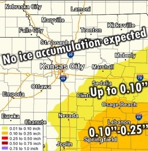
Freezing drizzle mixed with snow is possible currently through 3 a.m., the weather service said.
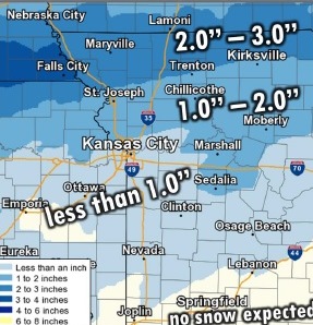
The Kansas City metropolitan area could experience freezing drizzle mixed with snow, the weather service said, with totals between a trace and 1 inch.
Precipitation may change to all snow by 2 a.m., according to the weather service. Larger amounts of snow are in the forecast for the northern border of the state and the St. Joseph, Missouri, area could get 1 to 2 inches.
Tonight’s low will be about 12, with a north wind of 7 to 10 mph, according to the weather service.
Sunday, there is a 20 percent chance of snow before 9 a.m. The high will be near 31 with a north northwest wind of 5 to 7 mph becoming west in the afternoon.
Sunday night, it will be clear with a low of 12 and a light and variable wind, according to the weather service.
Monday, it will be sunny with a high near 37 and an east wind of 3 to 8 mph, the weather service said.
Monday night, the low will be around 23 with an east wind of 7 to 9 mph, according to the weather service.
Tuesday, the high will be near 49 with mostly sunny skies, the weather service said.