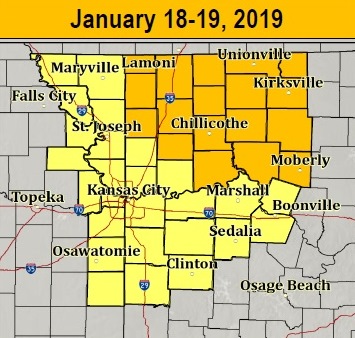
A winter weather advisory has been issued by the National Weather Service for 6 p.m. today through 3 p.m. Saturday in Wyandotte County.
A mix of rain, rain mixed with snow, and snow is expected with this storm, the weather service said.
A storm system is expected to come from the southern Rockies and track across the region later today through Saturday, according to the weather service.
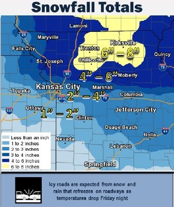
Expect widespread snow across the region, the weather service said. Along the Interstate 70 corridor including the KC metro area, 2 to 4 inches are in forecast for Friday and Saturday.
Residents should plan on slippery road conditions, and patchy blowing snow could significantly reduce visibility, according to the weather service. Snow on the roads, and rain that refreezes as temperatures drop tonight, will make for very slick road conditions, the weather service said. Motorists are asked to use caution.
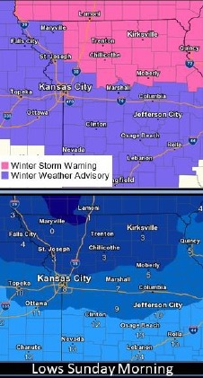
Dangerously cold temperatures and wind chills expected behind this system Saturday night into Sunday with lows in the single digits and wind chills in the single digits below zero, according to the weather service.
Light snow accumulations will again be possible on Tuesday, the weather service said.
Today, there is a 90 percent chance of rain and snow before 1 p.m., then rain, the weather service said. Areas of fog are possible before 11 a.m. The high will be near 36 with an east southeast wind of 10 to 14 mph, gusting as high as 18 mph. Little or no snow accumulation is expected during the day.
Tonight, there is a 100 percent chance of rain before 8 p.m., then rain and snow, possibly mixed with freezing rain, between 8 p.m. and 10 p.m., then snow after 10 p.m., according to the weather service. Patchy blowing snow is possible after midnight. The low will be around 18. It will be blustery, with a north wind of 11 to 16 mph increasing to 17 to 22 mph after midnight, and gusting as high as 34 mph. Little or no ice accumulation is expected. There could be new snow accumulation of 1 to 3 inches possible.
Saturday, there is a 20 percent chance of snow before noon, with patchy blowing snow possible before noon, the weather service said. Cloudy skies will change to mostly sunny, with a high near 19. The wind chill will be between zero and 5. It will be blustery, with a north northwest wind of 13 to 22 mph, gusting as high as 34 mph.
Saturday night, it will be mostly clear, with a low of 8, according to the weather service. The wind chill will be between zero and 5. A north northwest wind of 6 to 11 mph will become light and variable after midnight.
Sunday, it will be mostly sunny with a high near 30, the weather service said. A light and variable wind will become south 5 to 7 mph in the morning.
Sunday night, it will be partly cloudy with a low of 22, according to the weather service.
On Monday, Martin Luther King Jr. holiday, it will be mostly sunny, with a high near 44, the weather service said.
Monday night, it will be mostly cloudy with a low of 32, according to the weather service.
Tuesday, there is a 30 percent chance of rain and snow before noon, then a chance of snow, the weather service said. The high will be near 37.
Tuesday night, it will be mostly cloudy with a low of 16, according to the weather service.
Wednesday, it will be mostly sunny with a high near 28, the weather service said.
Wednesday night, it will be mostly cloudy, with a low of 19, according to the weather service.
Thursday, it will be mostly cloudy, with a high near 33, the weather service said.
For more information, visit www.weather.gov.