A winter weather advisory went into effect at 9 a.m. in the Kansas City area, according to the National Weather Service. The advisory expires at midnight.
A radar map from the National Weather Service at 9 a.m. is showing a line of storms located just to the northwest of Wyandotte County, extending from Marysville, Kan., to St. Joseph, Mo., to just northwest of Kansas City, through Sedalia, Mo., and into the Missouri Ozarks.
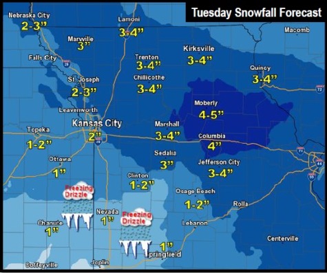
There is a chance for this storm system to reach Wyandotte County with flurries before 11 a.m., then snow after 11 a.m., the weather service said. Today’s high will be near 23.
The weather service said a second band of snow will form over east central Kansas by late morning and spread east during the afternoon.
The total snow accumulation today could be from 1 to 3 inches in Wyandotte County, according to the weather service.
Freezing drizzle is possible today, especially south of the Missouri River, the weather service said, and could precede the afternoon snow.
A snowstorm could continue during the afternoon and evening hours, making it particularly dangerous for evening rush-hour drivers. The rate of snow could be one inch per hour during the evening commute, the weather service said.
The snow should be tapering off tonight by about 9 p.m. It will end from west to east starting early this evening, according to the weather service.
Those who are on the roads during rush-hour traffic and the snowstorm today should be prepared for low visibility and slippery roads, according to the weather service.
There will be another chance of snow on Thursday, the weather service said.
For more weather information, visit www.weather.gov.