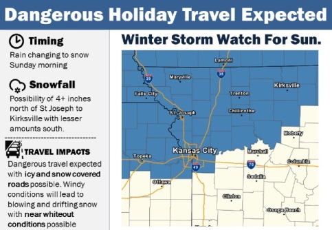
Rain is expected to change over to snow on Sunday morning, according to the National Weather Service.
Snow accumulations of more than 4 inches will be possible on Sunday north of a St. Joseph, Missouri, to Kirksville, Missouri, line with lesser amounts south, including 2 to 4 inches in the Kansas City metropolitan area, the weather service said.
This will lead to icy and snow covered roadways, according to the weather service. Travel could be dangerous on Sunday, the weather service said.
In addition to the snow, conditions are expected to be windy leading to blowing and drifting snow and causing occasional whiteout conditions, the weather service said.
Wyandotte County is under a winter storm watch from 6 a.m. through 9 p.m. Sunday, according to the weather service. In the Kansas City area, a rain and snow mix is possible between 7 a.m. and 9 a.m., followed by snow after 9 a.m. Sunday, the weather service said.
Weather forecasters are trying to pinpoint the exact time and location of the snow on Sunday, and residents are advised to check the forecast on Saturday for updated information.
Today, there is a 40 percent chance of showers, mainly before 1 p.m., the weather service said. The high will be near 51 with a south wind of 8 to 15 mph, gusting as high as 32 mph.
Tonight, it will be mostly clear with a low of 36 and a west southwest wind of 6 to 8 mph, according to the weather service.
Saturday, it will be mostly sunny with a high near 60, the weather service said. A light and variable wind will become south around 6 mph in the afternoon.
Saturday night, there is a 40 percent chance of showers after midnight, according to the weather service, with a low of 36. An east southeast wind of 6 to 11 mph will become north northeast after midnight. Winds may gust as high as 21 mph. Less than a tenth of an inch of precipitation is expected.
Sunday, there is a 90 percent chance of rain and snow. Rain showers are in the forecast before 7 a.m., followed by rain and snow showers between 7 a.m. and 9 a.m., followed by snow showers after 9 a.m., the weather service said. Patchy blowing snow is possible after 1 p.m. The high will be near 36 with a north northwest wind of 17 to 23 mph, with gusts as high as 36 mph. New snow accumulation of 2 to 4 inches is possible.
Sunday night, there is a 20 percent chance of snow showers before midnight, with a low of 20, according to the weather service.
Monday, it will be sunny with a high near 33, the weather service said.
Monday night, it will be mostly clear with a low of 20, according to the weather service.
Tuesday, the high will be near 38 with mostly sunny skies, the weather service said.
Tuesday night, it will be partly cloudy with a low of 23, according to the weather service.
Wednesday, it will be partly sunny with a high near 39, the weather service said.
Wednesday night, it will be mostly cloudy with a low of 27, according to the weather service.
Thursday, there is a 30 percent chance of rain and snow, with a high near 39, the weather service said.
For more information, visit www.weather.gov.