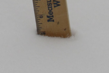
Wyandotte County is in the throes of a winter storm on Thursday morning, with about five inches of snow on the ground and more snow coming down through this afternoon.
The winter storm warning is in effect through 6 p.m. Thursday. From 3 to 7 inches of snow is possible today, according to the National Weather Service forecast.
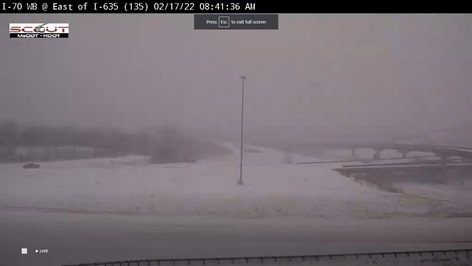
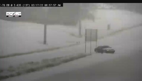
Multiple accidents were reported Thursday morning on area highways, according to KC Scout. Residents were advised not to go out if they don’t have to. Many schools canceled classes today. Several crashes were reported in the I-70 and I-635 area of Kansas City, Kansas. The exit from westbound I-70 to northbound I-635 was closed.
A wintry mix of sleet, freezing rain, snow and rain fell during the predawn hours, making the transition to snow this morning, the weather service said. The heaviest snow will be in the morning, through noon. The storm was moving toward the east.
Blowing and drifting snow with 20 to 25 mph winds and gusts to 35 mph will make driving difficult today.
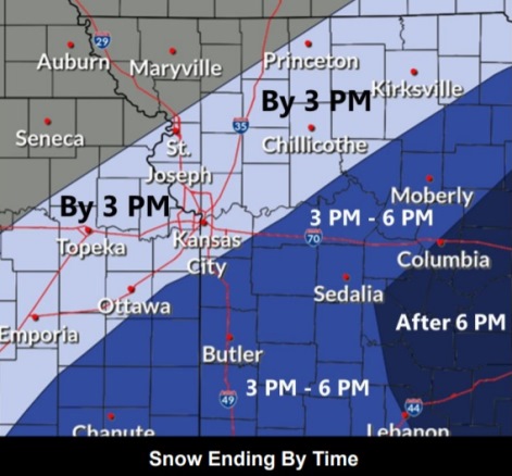
Snow will diminish between noon and 3 p.m. and should exit the area by 6 p.m.
The weather service advised people who must travel to take an extra flashlight, food and water in their vehicles in case of an emergency. The latest road conditions in Kansas are available by calling 5-1-1. For Kansas City area highway conditions, visit www.kcscout.net.
If you must travel, keep an extra flashlight, food, and water in
your vehicle in case of an emergency.
According to a post on the Unified Government website, all “hot routes” (major roads) and most secondary routes were treated with salt before switching to plowing operations in the early morning. Plowing will continue through this evening, and residents are encouraged to stay home.
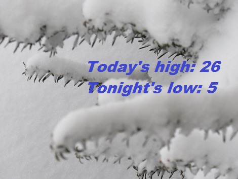
Today, there is a 100 percent chance of snow, mainly before 4 p.m. The snow could be heavy at times, and there will be areas of blowing snow before noon, the weather service said. The high will be near 26 with a north wind of 10 to 18 mph, gusting as high as 33 mph. From 3 to 7 inches of snow are possible.
Tonight, it will be mostly clear, with a low of 5, according to the weather service. A north northwest wind of 5 to 7 mph will become calm. Winds may gust up to 18 mph.
Friday, it will be sunny, with a high near 40, the weather service said. Wind chill values will be between zero and 10. A southwest wind of 6 to 15 mph will gust as high as 28 mph.
Friday night, it will be mostly clear, with a low of 20, according to the weather service. A southwest wind of 5 to 10 mph will become north northeast after midnight. Winds may gust as high as 18 mph.
Saturday, it will be sunny, with a high near 41, the weather service said. A northeast wind of 5 to 10 mph will become south southeast in the afternoon.
Saturday night, it will be mostly clear, with a low of 32, according to the weather service.
Sunday, it will be sunny, with a high near 56, the weather service.
Sunday night, it will be partly cloudy, with a low of 40, according to the weather service.
On Monday, Presidents Day, it will be partly sunny, with a high near 59, the weather service said.
Monday night, there is a 30 percent chance of rain before midnight, with a low of 27, according to the weather service.
Tuesday, there is a 30 percent chance of snow, with a high near 36, the weather service said.
Tuesday night, it will be mostly cloudy, with a low of 16, according to the weather service.
Wednesday, it will be partly sunny, with a high near 30, the weather service said.