Winter weather advisory in effect today
A winter weather advisory has been issued for freezing drizzle in Wyandotte County from 9 a.m. to 6 p.m. Dec. 16, according to the National Weather Service.
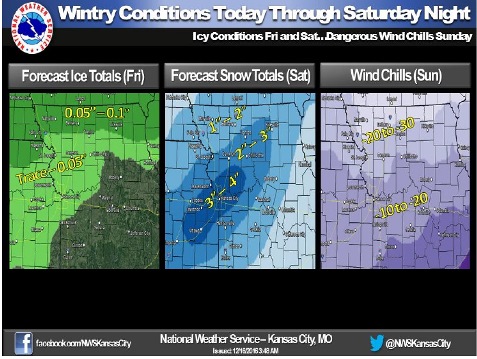
Freezing drizzle will be possible today, the weather service said.
Minor ice accumulation leading to slick roads will be possible south of St. Joseph, Mo. Ice accumulations up to a tenth of an inch will be possible north of St. Joseph, where freezing drizzle will last through the day into night.
Freezing drizzle will change to snow by late Saturday morning and will continue through Saturday evening, the weather service said.
A swath of 2 to 4 inches of snow will be possible across much of the forecast area, according to the weather service.
In the wake of this storm, dangerous wind chills will move into the area Sunday morning, the weather service said.
Wind chills of 10 to 20 degrees below zero are possible across the southern part of the forecast area, dropping to 20 to 30 below zero across the north, according to the weather service.
In Wyandotte County, the forecast calls for patchy freezing drizzle before 2 p.m. today, then patchy drizzle afterward, the weather service said. The high will be near 34. There will be a southeast wind of 9 to 14 mph, gusting to 21 mph.
At 8 a.m. today, the temperature was 31 degrees, with a wind chill of 20, according to the weather service.
Tonight, patchy drizzle is possible before midnight, then patchy freezing drizzle, the weather service said. The low will be around 221. An east wind of 5 to 10 mph will become north 11 to 16 mph after midnight. Winds may gust as high as 24 mph
Saturday, there is an 80 percent chance of freezing rain before 9 a.m., then snow, according to the weather service. The snow may be heavy at times, the weather service said. From 3 to 5 inches of snow is possible.
On Saturday, temperatures will fall to around 9 by 5 p.m., with wind chill values between minus 9 and minus 1, according to the weather service. A north northwest wind of 15 to 18 mph may gust as high as 26 mph.
On Saturday night, there is a 20 percent chance of snow before midnight, the weather service said. The low will be around minus 5. The wind chill will be between minus 10 and minus 19. A north northwest wind of 8 to 17 mph may gust as high as 26 mph.
Sunday, it will be sunny and cold, with a high near 12, according to the weather service. A north northwest wind of 5 to 7 mph will become south southwest in the afternoon. Sunday night, expect a low of around 3.
Monday, it will be sunny with a high near 30, according to the weather service. Monday night, the low will be around 15.
Tuesday, it will be sunny with a high near 38, the weather service said.