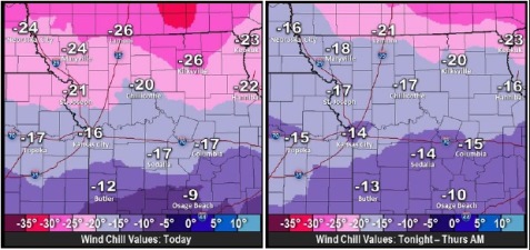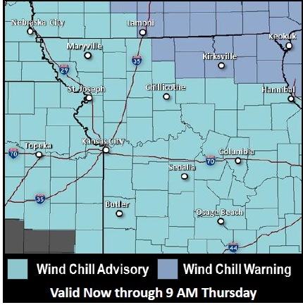
A wind chill advisory is in effect today through 9 a.m. Thursday, according to the National Weather Service.
The wind chill was minus 7 at 9 a.m. Wednesday, with the temperature at 9 degrees in Wyandotte County. There was a light dusting of snow overnight.
From now until 9 a.m. Thursday, the wind chill advisory in effect means that frostbite is a danger, the weather service said. Frostbite may occur in 30 minutes or less if skin is exposed, the weather service stated. Hats and gloves are needed along with warm winter coats.
Skies will be sunny today and the cold will continue, according to the weather service. A north wind of 15 to 20 mph will decrease to 9 to 14 mph in the afternoon. Winds may gust as high as 28 mph on Wednesday.
Tonight, the forecast is mostly clear with a low around minus 1. The wind chill will be between minus 7 and minus 14. The winds will be light and variable after midnight.
The coldest hours will be from 4 a.m. Thursday through 8 a.m. Thursday, the weather service said.
Thursday, the forecast is mostly sunny and a high of 25. The wind chill will be between minus 5 and minus 15. The south wind of 11 to 20 mph will change to the west in the afternoon. Winds may gust up to 30 mph.
Friday, the forecast is sunny and a high near 16. The wind will be 6 to 14 mph with gusts as high as 20 mph.
Saturday, the high will be near 29, and Sunday, the high will be near 34.