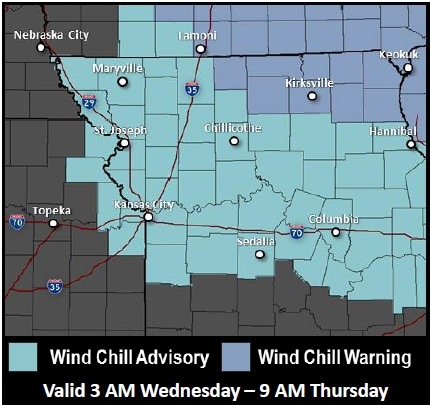
A wind chill advisory will be in effect from 3 a.m. Wednesday to 9 a.m. Thursday, according to the National Weather Service.
Today, the forecast states there will be a high of 19 degrees with mostly sunny skies. Wednesday, the high will be 7 degrees while overnight lows will range from 4 degrees to minus 1, according to the weather service forecast.
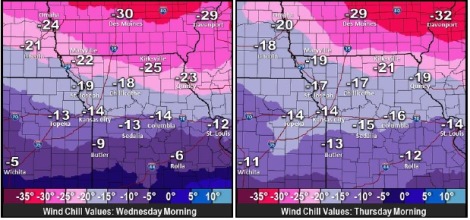
Wind chills in the area are expected to be 15 to 25 below zero during early Wednesday through Thursday morning, the weather service said. The coldest will be Wednesday morning and again early Thursday morning.
Temperatures will be between 0 and 5 below late tonight and again Wednesday night, the weather service said. Temperatures will not rise out of the single digits on Wednesday.
Winds will be 10 to 20 mph with gusts up to 30 mph, the weather service said. The strongest winds will be Wednesday morning and again Thursday morning.
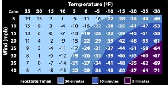
Frostbite can occur in 30 minutes or less if skin is exposed, according to the weather service.
There will be frostbite and hypothermia if precautions are not taken, the weather service said. If you must venture out, dress warmly and wear a hat and gloves, according to the weather service.
On Thursday, temperatures will climb again to 26 degrees. Friday’s high will be 18.