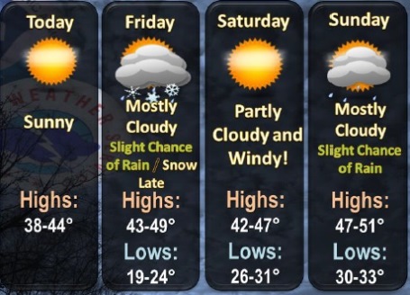
After a sunny day and a high of 43 on Thursday, weather will continue to be in the 40s through Sunday, according to the National Weather Service.
Friday’s high will be 46, Saturday, 45, and Sunday, 48, the weather service said. Temperatures start dropping again on Monday.
While there could be a brief rain or snow shower Friday night south of Kansas City, this activity should be insignificant, according to the weather service.
Rain or snow showers will be possible Sunday night and Monday, primarily east of the Kansas City metro area, the weather service said.
Today, a light south southwest wind will become west southwest 8 to 13 mph in the morning, according to the weather service. The low tonight will be 24.
Friday, the high will be near 46 with mostly cloudy skies, the weather service said. A light and variable wind will become south 5 to 9 mph in the morning.
Friday night, the low will be around 28, with a south wind around 7 mph changing to west northwest after midnight, according to the weather service.
Saturday will be mostly sunny with a high near 45 and a west northwest wind of 6 to 8 mph, the weather service said. Saturday night, the low will be around 34, with partly cloudy skies.
Sunday, expect mostly sunny skies with a high near 48, the weather service said. Sunday night, the low will be around 29 with mostly cloudy skies.
Monday will see a drop in the high temperature to 37, with partly sunny skies, according to the weather service. It will be breezy. Monday night, expect a low of 20.
Tuesday, the high will be a chilly 30 degrees with mostly sunny skies, the weather service said. Tuesday night’s low will be around 17.
On Wednesday, skies will be mostly sunny with a high near 37, according to the weather service.