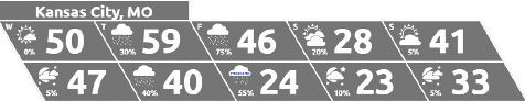
Wednesday began with a 32-degree temperature and a 22-degree wind chill reading at 9 a.m., but the weather should warm up to about 51 degrees later today, according to the National Weather Service forecast..
There is an elevated fire risk today, with winds gusting up to 26 mph, the weather service said.
The next chance for precipitation will be on Thursday when showers and a few thunderstorms will be possible, according to the weather service. Severe weather is not expected.
Temperatures will rise to about 60 degrees on Thursday before dropping to a high of about 46 on Friday. Temperatures continue dropping on Saturday, when the high will be about 23 degrees.
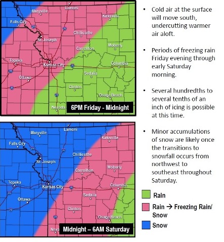
Rain on Friday is expected to change over to freezing rain Friday night into Saturday morning, the weather service said. By mid-morning Saturday, light snow is expected across the outlook area.
Today, it will be sunny with a high near 51 and a southeast wind of 13 to 15 mph, gusting as high as 26 mph, the weather service said.
Tonight, it will be partly cloudy, with a low of 45, according to the weather service. It will be breezy, with a south wind of 13 to 22 mph, gusting to 34 mph.
Thursday, there is a 30 percent chance of showers or drizzle before noon, then a chance of showers after noon, the weather service said. The high will be near 60, with a south southwest wind of 18 to 23 mph decreasing to 8 to 13 mph in the afternoon. Winds may gust as high as 36 mph. Less than a tenth of an inch of precipitation is expected.
Thursday night, there is a 50 percent chance of showers before midnight, then a chance of rain after midnight, according to the weather service. The low will be around 39. The wind will be calm. Less than a tenth of an inch of precipitation is expected.
Friday, there is a 90 percent chance of rain, with a high near 46, the weather service said. A light northeast wind will become north northeast 6 to 11 mph in the morning. Winds may gust as high as 25 mph. Between a quarter and half-inch of rain is possible.
Friday night, there is a 70 percent chance of rain, possibly mixed with freezing rain before 11 p.m., then freezing rain is likely, possibly with snow, according to the weather service. The low will be around 20. Between a tenth and quarter-inch of precipitation is possible.
Saturday, there is a 30 percent chance of snow before noon, with a high near 23, the weather service said.
Saturday night, it will be mostly clear, with a low of 17, according to the weather service.
Sunday, it will be mostly sunny, with a high near 42, the weather service said.
Sunday night, it will be mostly cloudy, with a low of 27, according to the weather service.
Monday, it will be partly sunny, with a high near 45, the weather service said.
Monday night, it will be mostly cloudy, with a low of 29, according to the weather service.
Tuesday, it will be partly sunny, with a high near 45, the weather service said.