A wind chill advisory is in effect until noon today in Wyandotte County, and another wind chill advisory has been issued for 9 p.m. tonight until noon Saturday, according to the National Weather Service.
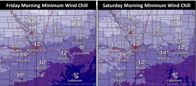
The temperature was 2 degrees at 9 a.m. Friday, with a wind chill of minus 16, the weather service said.
The extreme cold could cause frostbite on exposed skin in as little as 30 minutes, according to the weather service. Dangerous wind chills will remain possible for the weekend into early next week.
Residents are advised to use caution while traveling outside. They should wear appropriate clothing, a hat and gloves, according to the weather service.
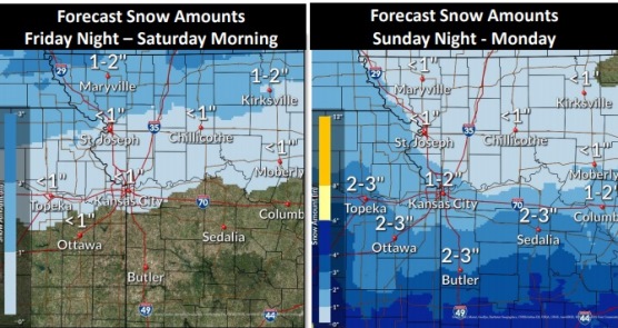
A slight chance of snow will increase through the afternoon, continuing overnight into early Saturday morning, the weather service said.
There is a 30 percent chance of snow tonight, then on Sunday and Sunday night, there will be a 40 percent chance of snow, according to the forecast.
Additional accumulating snow is possible by Sunday afternoon through Monday, with the best chance for accumulation south of I-70, the weather service said.
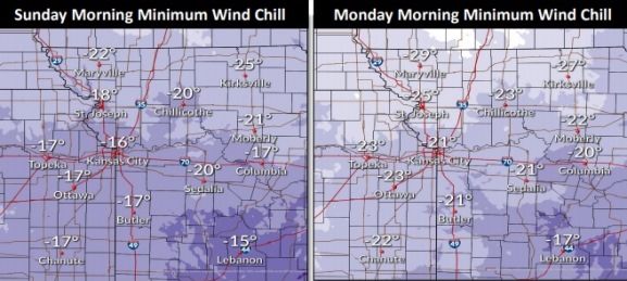
Dangerously cold wind chills are expected Monday morning, ranging from minus 20 to minus 30, according to the weather service.
Today, there is a 20 percent chance of snow after 4 p.m., with a high near 10 during the day. The wind chill will be between minus 5 and minus 12. There will be a north northeast wind of 10 to 13 mph.
Tonight, there is a 30 percent chance of snow, mainly between 7 p.m. and 4 a.m., according to the weather service. The low will be around 1, with wind chill values of between minus 5 and minus 12. A north northeast wind will be around 10 mph.
Saturday, it will be mostly cloudy and cold, with a high near 8 and wind chill values between minus 5 and minus 15, the weather service said. A north northeast wind will be around 10 mph.
Saturday night, it will be mostly cloudy, with a low of minus 2 and wind chill values between minus 7 and minus 16, according to the weather service. A north northeast wind will be around 10 mph.
Sunday, there is a 40 percent chance of snow, with a high near 5, the weather service said. A north northeast wind of 10 to 14 mph will could as high as 18 mph.
Sunday night, there is a 40 percent chance of snow, mainly before midnight, with a low of minus 8, according to the weather service.
On Monday, Presidents Day, it will be mostly cloudy and cold, with a high near 2, the weather service said.
Monday night, it will be mostly cloudy with a low of minus 10, according to the weather service.
Tuesday, it will be partly sunny and cold, with a high near 12, the weather service said.
Tuesday night, it will be mostly cloudy, with a low of 4, according to the weather service.
Wednesday, it will be mostly cloudy, with a high near 23, the weather service said.
Wednesday night, it will be mostly cloudy, with a low of 4, according to the weather service.
Thursday, it will be partly sunny, with a high near 24, the weather service said.
For more weather information, visit www.weather.gov.