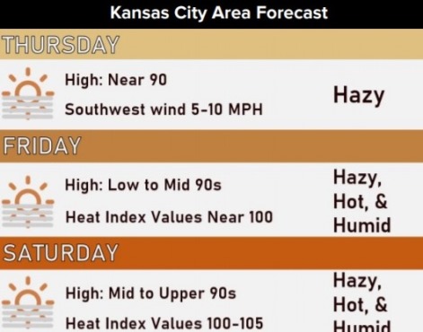
Today’s high will be near 89, but the weather is about to get dangerous on Friday, according to the National Weather Service forecast.
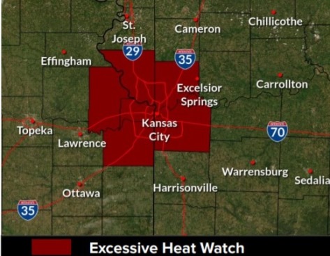
On Friday, an excessive heat watch goes into effect at 1 p.m., lasting until 7 p.m. Wednesday, July 28, according to the weather service.
Dangerous heat will build into the area this weekend and likely persist through late next week, the weather service said.
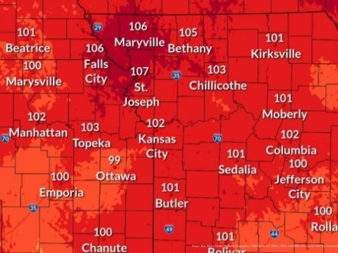
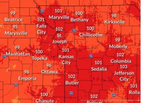
The heat index will be in the 100 to 105 range this weekend through late next week, according to the weather service.
Low temperatures will only fall into the mid to upper 70s overnight from tonight through Tuesday night, with only minimal relief from the heat, the weather service said.
The weather service advised residents to monitor the latest forecasts and warnings for updates. Residents should drink plenty of fluids, stay in an air-conditioned room, stay out of the sun and check up on relatives and neighbors, according to the weather service.
Young children and pets should never be left unattended in vehicles under any circumstances, the weather service said. This is especially true during warm or hot weather when car interiors can reach lethal temperatures in a matter of minutes.
The Unified Government has a list of cooling centers online, including many of the community centers, at https://unifiedgov.maps.arcgis.com/apps/LocalPerspective/index.html?appid=05d96f432cd645f6a59512875df09d6b.
Today, it will be sunny with a high near 89, the weather service said, and a south southwest wind of 5 to 8 mph.
Tonight, it will be mostly clear, with a low of 72 and a south wind of 5 to 7 mph, according to the weather service.
Friday, it will be sunny, with a high near 93 and heat index values as high as 98, the weather service said. A south southwest wind will be 6 to 9 mph.
Friday night, it will be mostly clear, with a low of 74 and a south wind of 8 mph, according to the weather service.
Saturday, it will be sunny and hot, with a high near 97 and a southwest wind of 7 mph, the weather service said.
Saturday night, there is a 20 percent chance of showers after 8 p.m., with a low of 75, according to the weather service.
Sunday, there is a 30 percent chance of showers after 2 p.m., with a high near 95, the weather service said.
Sunday night, there is a 40 percent chance of showers before 8 p.m., then a chance of showers and thunderstorms after 2 a.m., according to the weather service. The low will be around 73.
Monday, there is a 40 percent chance of showers and storms, with a high of 91, the weather service said.
Monday night, there is a 30 percent chance of showers before 8 p.m., with a low of 73, according to the weather service.
Tuesday, it will be mostly sunny, with a high near 94, the weather service said.
Tuesday night, it will be mostly clear, with a low of 73, according to the weather service.
Wednesday, it will be sunny, with a high near 95, the weather service said.
For more information, visit www.weather.gov.