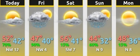
Cooler temperatures have arrived, with today’s high near 52, according to the National Weather Service.
The cooler temperatures are expected through the coming weekend, with overnight lows dipping into the 30s, the weather service said. This could result in some frost in exposed, rural areas.
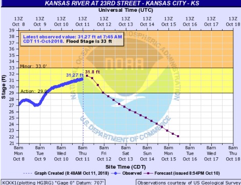
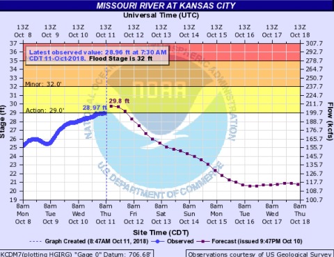
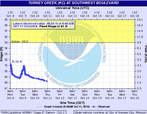
Flooding is still a concern, according to the weather service.
The next chance for rain arrives on Friday, and lasts through the weekend, according to the weather service. Any flooding that is still ongoing this weekend could last into early next week as a result, the weather service said. With the remnants of storm Sergio moving into the area on Saturday night into Sunday, there will be more rain and a cold front.
Depending on when precipitation falls late Sunday night into Monday morning, there could be some very light snow, according to the weather service. However, forecast models are unsure at this time, and it is more likely that there will be rain than snow.
A high pressure system will move in behind the front, with dry weather and cooler temperatures expected for much of next week.
Today’s forecast is partly sunny changing to sunny, with a high near 52 and a northwest wind of 7 to 10 mph, the weather service said.
Tonight, there is a 60 percent chance of showers, mainly after 5 a.m., according to the weather service. The low will be around 42 with a north northwest wind of 5 mph becoming calm in the evening. Less than a tenth of an inch of rain is expected.
Friday, there will be a 90 percent chance of showers, mainly before 1 p.m., the weather service said. The high will be near 47 with an east wind of 5 mph becoming calm in the afternoon. Between a tenth and quarter-inch of rain is possible.
Friday night, it will be mostly cloudy, with a low of 40, according to the weather service, and an east wind of 5 mph becoming calm in the evening.
Saturday, it will be mostly sunny with a high near 56 and a south wind of 6 to 9 mph, the weather service said.
Saturday night, there will be a 20 percent chance of showers with a low of 41, according to the weather service.
Sunday, there is an 80 percent chance of showers, mainly after 1 p.m., with a high near 43, the weather service said.
Sunday night, there is a 50 percent chance of showers before 4 a.m., then a chance of rain and snow showers, according to the weather service. The low will be around 33.
Monday, there is a 30 percent chance of snow showers before 7 a.m., with a high near 46, the weather service said.
Monday night, there will be widespread frost, mainly after 3 a.m., with a low of 34, according to the weather service.
Tuesday, there will be areas of frost, with a high near 57, the weather service said.
Tuesday night, it will be mostly clear with a low of 38, according to the weather service.
Wednesday, it will be sunny with a high near 60, the weather service said.
For more weather information, see www.weather.gov.