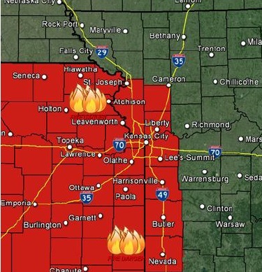
After an overnight freeze, the Wyandotte County area will have a red flag warning from 1 p.m. to 7 p.m. today, according to the National Weather Service.
A red flag warning means that critical fire weather conditions are either occurring now or will shortly, the weather service said.
The conditions include high winds, low humidity and dryness.
Residents are asked to avoid outdoor burning, according to the weather service.
Also, an elevated fire weather threat continues through Wednesday, according to the weather service.
Thunderstorms are possible Wednesday afternoon and early evening, the weather service said. Strong storms are possible generally east of I-35.
Today’s forecast will include sunny skies, a high near 65, and south southwest winds of 8 to 13 mph increasing to 20 to 25 mph in the afternoon, according to the weather service. Winds may gust as high as 34 mph.
Tonight, the low will be around 48. A south southwest wind of 18 to 21 mph will gust as high as 29 mph, the weather service said.
Tuesday, expect mostly sunny skies with a high near 77, according to the weather service. It will be breezy, with a south southwest wind of 17 to 21 mph, gusting to as high as 29 mph.
Tuesday night, the low will be around 59, with a south southwest wind of 21 mph, gusting as high as 29 mph, the weather service said.
On Wednesday, the low will be around 59 with partly cloudy skies, according to the weather service. A south southwest wind will be around 21 mph, gusting as high as 29 map.
On Wednesday night, the low will be around 34 with a 50 percent chance of showers, the weather service said.
Thursday, the high will be near 45, and Thursday night, the low will be around 31, the weather service said.
Friday’s high will be around 58, with the low on Friday night about 41, according to the weather service.