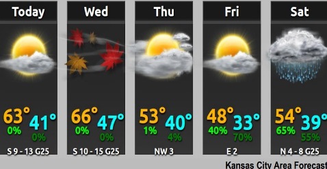
Near record-high temperatures are expected through Christmas Day, Dec. 25, with highs in the mid to upper 60s, according to the National Weather Service.
Winds will increase today and Wednesday with gusts in the 25-30 mph range, the weather service said.
Rain may return to the area Saturday, according to the weather service.
Today, it will be mostly sunny, with a high near 62 and a south wind of 9 to 13 mph, gusting as high as 25 mph, the weather service said.
Tonight, it will be partly cloudy, with a low of 46 and a south southwest wind of 10 to 13 mph, according to the weather service.
Wednesday, Christmas Day, it will be mostly sunny, with a high near 64 and a south wind of 10 to 16 mph, gusting as high as 26 mph.
Wednesday night, it will be partly cloudy, with a low of 40, and a south southwest wind of 5 to 9 mph, becoming light and variable after midnight, according to the weather service. Winds could gust as high as 23 mph.
Thursday, it will be partly sunny, with a high near 52 and a calm wind, the weather service said.
Thursday night, it will be mostly clear, with a low of 31, according to the weather service.
Friday, it will be mostly sunny, with a high near 48, the weather service said.
Friday night, there is a 70 percent chance of rain, mainly after midnight, according to the weather service. The low will be around 38.
Saturday, there is a 60 percent chance of rain, with a high near 54, the weather service said.
Saturday night, there is a 50 percent chance of rain, with a low of 32, according to the weather service.
Sunday, there is a 30 percent chance of rain and snow, with a high near 41, the weather service said.
Sunday night, it will be partly cloudy, with a low of 26, according to the weather service.
Monday, it will be mostly sunny, with a high near 41, the weather service said.