Heavy rains are in the forecast from today through Saturday, according to the National Weather Service.
The heavy rains could aggravate flooding along the Missouri River, according to forecasters.
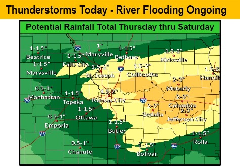
In Wyandotte County, heavy rains and thunderstorms could take place on Thursday afternoon, according to the weather service. Heavy rains and storms are again possible on Friday, possibly lingering into Saturday. From 1.5 to 2 inches of rain is expected, forecasters said.
Rainfall today and Friday will greatly aggravate ongoing flooding all along the Missouri River, but also will likely results in the development of additional flooding in rivers and streams across the region, the weather service stated.
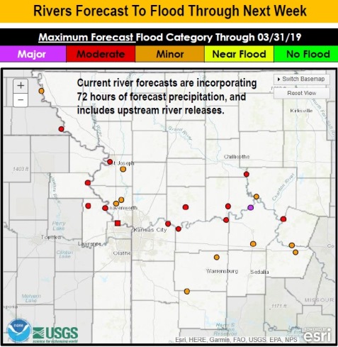
The Corps of Engineers and the National Weather Service said in a news conference on Wednesday afternoon that the rain in the coming three days could make the flooding worse in some areas on the Missouri River.
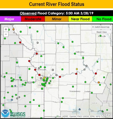
The Missouri River is currently in moderate flood stage, but declining, in Wyandotte County. The river level declined Wednesday in the Kansas City area, but conditions including the rain, runoff coming from streams to the north and water releases also will be a factor.
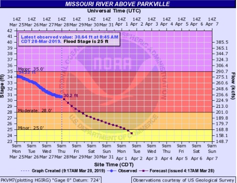
The water releases from the Gavins Point reservoir in South Dakota were increased from 33,000 cubic feet per second Wednesday to a scheduled 36,000 cfs Thursday, then scheduled to be increased to 39,000 cfs on Sunday and 42,000 cfs on next Wednesday. It takes around five days for the water releases to get to Kansas City. The reservoirs upstream are experiencing additional inflows from melting snow and other rivers.
It’s possible that Wyandotte County, Kansas City and other cities upstream and downstream on the river, such as St. Joseph, Missouri, could experience more flooding. Boonville, Missouri, and Jefferson City, Missouri, could experience two river crests, according to forecasters.
The forecasters said in Kansas City the three days of rain would increase the Missouri River by about 2 feet. The forecasts now include the next 72 hours of precipitation.
On Thursday morning, the river was in moderate flood stage at 30.64 feet at the I-435 gauge, near the Wolcott area, and it was projected to decline into minor flood stage on Friday evening, and out of flood stage on Monday evening. Major flood stage is 35 feet at that point at I-435. Two other flood gauges, one for the Missouri at Kansas City south of the downtown airport, and one at the Kansas River at 23rd, near Kansas Avenue at the state line, have dropped below minor flood stage.
If there are heavy rains with saturated ground, flash flooding also could be a possibility.
Temperatures here will be springlike and in the 60s today, then dropping into the 50s on Friday, and 38 on Friday night. Those who have put their garden plants outdoors already will want to take note that Saturday night, the low will be around 27, and Sunday night, the low will be 31, before rebounding on Monday and Tuesday.
Today, there is an 80 percent chance of showers and thunderstorms, with a high near 67. A south southwest wind of 6 to 9 mph will become east southeast in the afternoon, with winds gusting as high as 20 mph. New rainfall amounts between a quarter and half-inch of rain are possible. Light rain is possible until 2 p.m., when heavier rain could occur.
Tonight, there is an 80 percent chance of showers before 10 p.m., then showers and possibly a thunderstorm between 10 p.m. and 1 a.m., followed by more showers and thunderstorms after 1 a.m. The low will be around 50, with an east northeast wind of 7 to 9 mph. Between a quarter and half-inch of rain is possible.
Friday, there is a 90 percent chance of showers and precipitation before 1 p.m., then more showers and thunderstorms from 1 to 4 p.m., followed by showers and possibly a thunderstorm after 4 p.m., the weather service said. The high will be near 53 with a northeast wind of 9 to 11 mph. New rainfall between a quarter and half-inch of rain are possible.
Friday night, there is an 80 percent chance of showers and possibily a thunderstorm before 1 a.m., then a chance of showers, with a low of 38, according to the weather service. A north wind of 9 to 15 mph will gust as high as 29 mph. New rainfall amounts between a quarter and half-inch are possible.
Saturday, there is a 50 percent chance of showers, mainly before 1 p.m., the weather service said. The high will be near 46 with a north wind of 14 mph, gusting as high as 24 mph. Less than a tenth of an inch of rain is expected.
Saturday night, it will be mostly clear with a low of 27, according to the weather service.
Sunday, it will be sunny with a high near 50, the weather service said.
Sunday night, it will be mostly clear with a low of 31, according to the weather service.
Monday, it will be mostly sunny, with a high near 56, the weather service said.
Monday night, it will be mostly clear, with a low of 39, according to the weather service.
Tuesday, it will be sunny, with a high near 64, the weather service said.
Tuesday night, it will be partly cloudy, with a low of 48, according to the weather service.
Wednesday, there is a 30 percent chance of showers, with a high near 67, the weather service said.
To see charts of flooding along the Missouri River, visit https://water.weather.gov/ahps2/forecasts.php?wfo=EAX&fcst_timeframe=0¤t_color=flood¤t_type=all&fcst_type=fcst&conus_map=d_map¢er_point_lat=39.287545999997995¢er_point_lon=-94.18579099999516&default_zoom=8&marker=false.