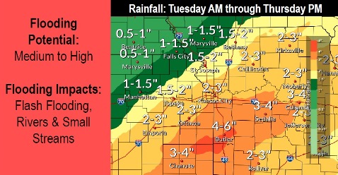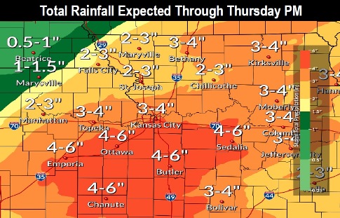
Wyandotte County could see from 2 to 3 ¾ inches of rain from now through Wednesday night, with the possibility of flash flooding, according to the National Weather Service forecast.
The weather service is calling for 3 to 6 inches through Thursday of rainfall possible along and south of the Missouri River, with 1 to 2 inches by Tuesday morning, and an additional 3 to 4 inches possible Tuesday to Thursday in the region. Heaviest amounts could be south of I-70.
The heaviest rains at this time appear to be in Tuesday’s forecast, when 1 to 2 inches of rain are possible, the weather service said.
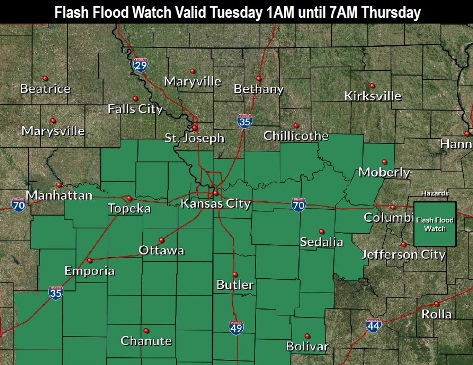
Flash flooding will be possible on Tuesday, with the flash flood watch in effect from 1 a.m. April 30 until 7 a.m. May 2, according to the weather service.
Several rounds of moderate to heavy rain in the forecast, as large amounts of moisture lift north from the Gulf of Mexico, the weather service said.
This heavy rainfall, combined with saturated soils, may lead to flooding of creeks, streams and low water crossings, according to the weather service. If you come across a flooded roadway, turn around, don`t drown.
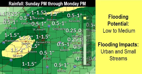
More rain is in the forecast for Saturday night and Sunday, the weather service said.
River flooding also could be possible on the Missouri River in the future, according to the weather service. Currently, the river levels in Wyandotte County are below flood stage and below action stage.
Today, there is a 40 percent chance of showers and thunderstorms before 10 a.m. The high will be near 67 with a north wind of 10 to 16 mph, gusting as high as 24 mph, the weather service said. Less than a tenth of an inch of rain is possible.
Tonight, there is an 80 percent chance of showers before 10 p.m., then a chance of showers and thunderstorms between 10 p.m. and 1 a.m., then showers and possibly a thunderstorm after 1 a.m., according to the weather service. Some of the storms could produce heavy rain. The low will be around 52 with a north northeast wind of 9 mph. Between a quarter and half-inch of rain is possible.
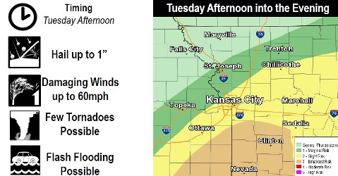
Tuesday, there is a 90 percent chance of showers and possibly a thunderstorm. Some of the storms could be severe. The high will be near 68 with a south southeast wind of 13 to 20 mph, gusting as high as 28 mph. New rainfall amounts will be between 1 and 2 inches.
Tuesday night, there is a 70 percent chance of showers and thunderstorms likely before 4 a.m., then a chance of showers. Some of the storms could be severe. The low will be around 52, with a south southeast wind of 7 to 9 mph, becoming northwest after midnight. Between a half and three-quarters of an inch of rain is possible.
Wednesday, there is a 20 percent chance of showers, with thunderstorms also possible after 4 p.m., the weather service said. The high will be near 69 with a north wind of 5 to 7 mph becoming southeast in the afternoon.
Wednesday night, there is a 60 percent chance of showers and thunderstorms, then showers are likely after 1 a.m., according to the weather service. The low will be around 54 with a quarter to a half-inch of rain possible.
Thursday, there is a 30 percent chance of showers before 1 p.m., with a high near 67, the weather service said.
Thursday night, it will be partly cloudy, with a low of 47, according to the weather service.
Friday, it will be mostly sunny with a high near 71, the weather service said.
Friday night, the low will be 52 with partly cloudy skies, according to the weather service.
Saturday, it will be sunny with a high near 75, the weather service said.
Saturday night, there is a 40 percent chance of showers with a low of 57, according to the weather service.
Sunday, the high will be near 76 with a 30 percent chance of showers, the weather service said.
For more weather information, visit www.weather.gov.