Wyandotte County is out of the heat wave today, with a high near 80 in the forecast, according to the National Weather Service.
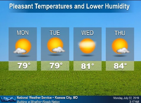
This week’s forecast includes highs in the 80s, without rain, a cooler and drier high pressure area that will dominate the weather throughout the week, the weather service said.
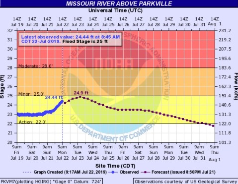
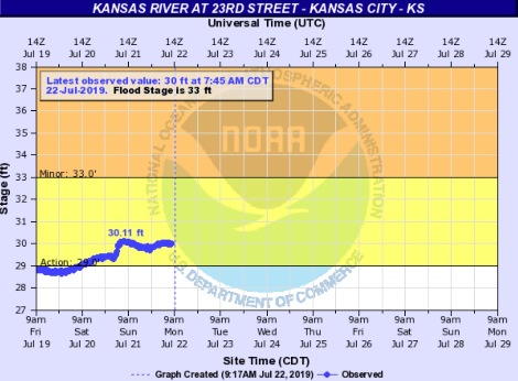
The Missouri and Kansas rivers in Wyandotte County are currently in action stage, and below flood stage, according to hydrology charts. They have risen slightly in the past few days.
Today, it will be sunny with a high near 80 and a north wind of 10 mph, the weather service said.
Tonight, it will be mostly clear, with a low of 60 and a north wind of 3 to 8 mph, according to the weather service.
Tuesday, it will be sunny with a high near 80 and a north northeast wind of 3 to 6 mph, the weather service said.
Tuesday night, it will be mostly clear, with a low of 59 and a calm wind, according to the weather service.
Wednesday, there may be patchy fog before 7 a.m. It will be sunny with a high near 83 and a calm wind, the weather service said.
Wednesday night, it will be mostly clear, with a low of 62, according to the weather service.
Thursday, it will be sunny, with a high near 85, the weather service said.
Thursday night, it will be mostly clear with a low of 66, according to the weather service.
Friday, it will be mostly sunny with a high near 87, the weather service said.
Friday night, it will be partly cloudy, with a low of 68, according to the weather service.
Saturday, it will be mostly sunny, with a high near 89, the weather service said.
Saturday night, it will be partly cloudy with a low of 71, according to the weather service.
Sunday, it will be mostly sunny, with a high near 90, the weather service said.