Temperatures were 14 degrees at 9 a.m. with a wind chill reading near 9, but should climb out of the deep freeze today, reaching 33 degrees by the afternoon, according to the National Weather Service forecast.
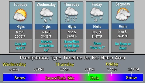
Snow also is in the forecast this week, with flurries possible before 10 a.m. Tuesday, and also overnight and into Wednesday morning, the weather service said. Every day of the forecast through Friday lists snow as a possibility.
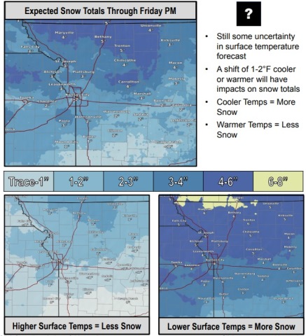
A shift of just a few degrees in the temperature could result in changes to the amount of snow that is predicted, according to the weather service. A cold front will move into the area on Thursday night.
Saturday and Sunday, however, are forecast to be clear, with highs of 38 and 45, according to the weather service forecast.
Today, scattered flurries are possible before 10 a.m., the weather service said. The high will be near 33 with a south wind of 6 to 11 mph.
Tonight, there is a 70 percent chance of snow, mainly after 3 a.m., according to the weather service. The low will be around 31 with a south wind of 9 to 13 mph. New snow accumulation of less than a half-inch is possible.
Wednesday, there is a 90 percent chance of snow before 11 a.m., then rain and snow between 11 a.m. and 3 p.m., then rain after 3 p.m., the weather service said. The high will be near 37 with a south wind of 11 to 14 mph, gusting as high as 20 mph. New snow accumulation of around an inch is possible.
Wednesday night, there is a 50 percent chance of rain and snow before 2 a.m., then a chance of rain between 2 a.m. and 5 a.m., then rain and snow after 5 a.m., according to the weather service. The low will be 34 with a south wind of 5 to 10 mph becoming light after midnight. Between a tenth and quarter-inch of precipitation is possible.
Thursday, there is a 50 percent chance of rain and snow before 11 a.m., then a chance of rain, the weather service said. The high will be near 38 with a calm wind. Between a tenth and quarter-inch of precipitation is possible.
Thursday night, there is a 50 percent chance of rain before 7 p.m., then a chance of rain and snow between 7 p.m. and 11 p.m., then a chance of snow after 11 p.m., according to the weather service. The low will be around 28. Less than a tenth of an inch of precipitation is forecast.
Friday, there is a 30 percent chance of snow before noon, with a high near 34, the weather service said.
Friday night, it will be mostly cloudy with a low of 29, according to the weather service.
Saturday, it will be mostly cloudy, with a high near 38, the weather service said.
Saturday night, it will be partly cloudy, with a low of 27, according to the weather service.
Sunday, it will be mostly sunny, with a high near 45, the weather service said.
Sunday night, it will be partly cloudy, with a low of 30, according to the weather service.
Monday, it will be mostly cloudy, with a high near 48, the weather service said.