The National Weather Service has issued a severe thunderstorm warning for Wyandotte, Leavenworth and Johnson counties until 8:30 p.m.
At 7:26 p.m., Doppler radar was tracking a line of strong thunderstorms along a line extending from Ozawkie to near Wiliamstown to near Centropolis, and moving east at 35 mph.
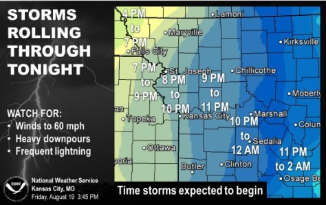
Wind gusts from 40 to 50 mph will be possible with these storms during the next 45 minutes, the weather service.
At 7:58 p.m., severe thunderstorms were located along a line extending from 7 miles west of Lansing to near Bonner Springs to near Gardner, moving east at 35 mph.
The storms include 60 mph wind gusts.
Residents are advised to move to an interior room on the lowest floor of a building, the weather service said.
Bonner Springs, Edwardsville and Kansas City, Kan., are among the cities that are in the path of the storm.
High winds are possible and roof damage is possible, according to the weather service.