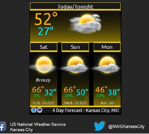
Temperatures today may reach a high of 53, and highs on Saturday and Sunday could reach 66, the National Weather Service said.
There will be a slightly elevated fire danger this weekend because of higher than normal temperatures and high south to southwest winds, according to the weather service.
The next chance for precipitation will come Sunday night into Monday when rain will be possible, the weather service said.
Temperatures will drop 20 degrees from Sunday to Monday, according to the weather service.
The temperature was 33 degrees at 8 a.m. Friday, and is expected to rise to the low 50s around 3 p.m.
Today, it will be partly sunny, with a high near 53, the weather service said. A west southwest wind of 8 to 15 mph will become north northwest in the afternoon, with winds gusting as high as 23 mph.
Tonight, it will be mostly clear, with a low around 32 and a north wind of 5 to 8 mph, becoming calm.
Saturday, it will be sunny with a high near 66, the weather service said. A south wind of 5 to 10 mph will increase to 11 to 16 mph in the afternoon, with winds gusting as high as 24 mph.
Saturday night, it will be partly cloudy, with a low of 49, according to the weather service. A south southwest wind of 9 to 14 mph will gust as high as 28 mph.
Sunday, it will be partly sunny, with a high near 66, the weather service said. A south southwest wind of 6 to 11 mph will become light southwest in the afternoon, with winds gusting as high as 23 mph.
Sunday night, there is a 20 percent chance of rain before midnight, with a low around 38, according to the weather service.
Monday, there is a 30 percent chance of rain after noon, with a high near 46, the weather service said.
Monday night, look for mostly cloudy skies with a low of 30, according to the weather service.
For more weather information, visit www.weather.gov.