Scattered to numerous thunderstorms are expected along a cold front Saturday evening and overnight across the entire outlook area, according to the National Weather Service.
Some of these storms could become strong to severe, the weather service said.
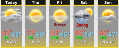
Today’s high will be near 63, with mostly cloudy skies gradually becoming sunny, the weather service said. A northwest wind of 6 mph will become calm in the afternoon.
Tonight, the low will be around 47 with mostly clear skies and a light southeast wind, according to the weather service.
Thursday, there may be patchy fog before 10 a.m., the weather service said. The skies later will be sunny with a high of 74, and a south southeast wind of 5 to 10 mph.
Thursday night, it will be mostly clear, with a low of 60 mph and a south wind of 7 mph, according to the weather service.
Friday, it will be sunny with a high of 84, and a south wind of 7 to 11 mph, the weather service said.
Friday night, there is a 50 percent chance of storms and rain, mainly after 1 a.m., according to the weather service. The low will be around 64. Less than a tenth of an inch of rain is expected.
Saturday, there is a 50 percent chance of showers and thunderstorms, with a high near 82, the weather service said.
Saturday night, there is an 80 percent chance of showers and thunderstorms, according to the weather service. A thunderstorm is possible after 1 a.m. The low will be 56.
Sunday, there is a 30 percent chance of showers before 1 p.m., the weather service said. The high will be near 85.
Sunday night, it will be mostly clear, with a low of 46, according to the weather service.