Warm temperatures today through Thursday will precede a cooling trend on Friday and through the holiday weekend, according to the National Weather Service.
The Christmas Eve forecast will be a low of 12 degrees, while on Christmas Day, Dec. 25, the high will be near 27 degrees, according to the weather service.
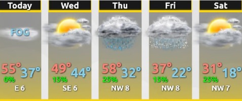
Today, there will be areas of fog before 11 a.m., followed by a mostly sunny day with a high near 55, the weather service said. A west southwest wind of 6 mph will become light and variable.
Tonight, the low will be around 36 with an east northeast wind of 7 mph, according to the weather service.
Wednesday, it will be partly sunny with a high near 49 and an east wind of 5 to 7 mph, the weather service said.
Wednesday night, the low will be around 43 with a southeast wind of 5 to 8 mph, according to the weather service.
Thursday, there is a 30 percent chance of showers before noon, then a slight chance of drizzle after noon, the weather service said. The high will be near 58 with a southeast wind of 6 to 8 mph becoming north northwest in the afternoon.
Thursday night, the low will be around 28, according to the weather service, with mostly cloudy skies.
Friday, there is a large drop in the temperature; the high will be near 35 with mostly cloudy skies, the weather service said.
Friday night, the low will be around 21 with partly cloudy skies, according to the weather service.
Saturday, the high will be near 31 with partly sunny skies, the weather service said.
Saturday night, the low will be around 16 with mostly cloudy skies, according to the weather service.
Sunday, there is a 30 percent chance of snow showers with a high near 30, the weather service said.
Sunday night, Christmas Eve, expect a low of 12 with partly cloudy skies, according to the weather service.
On Christmas Day, Dec. 25, skies will be mostly sunny with a high near 27, the weather service said.