Very little, if any snow was noticed after the Wyandotte County area received a tiny bit of precipitation Wednesday evening and Thursday morning.
Residents today have to deal with bitterly cold temperatures as high pressure moves into the area, the National Weather Service said.
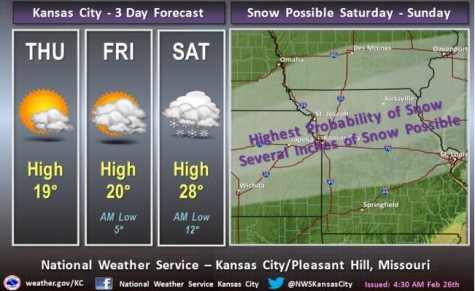
There are increasing chances of snow this weekend, according to the weather service.
The temperature was 11 degrees with a wind chill of minus 5 at 8 a.m. Thursday, according to the weather service.
Today’s high in Wyandotte County may reach 16, the weather service said. A north wind will be 13 to 17 mph with gusts as high as 28 mph, according to the weather service.
Tonight, the low will be around 3.
Friday’s forecast is mostly sunny with a high of 19, the weather service said. The wind chill will be between minus 5 and 5.
Friday night, it will be mostly cloudy with a low around 12, according to the weather service.
Saturday, expect snow after noon, the weather service said. The high will be near 27. The chance of precipitation is 70 percent and there will be 1 to 3 inches possible of snow, although that amount is not yet certain, according to the weather service.
The 70 percent chance of snow continues Saturday night, the weather service said. On Sunday, the chance of rain and snow is 60 percent, with a high of 35, according to the weather service.
Monday, there is a 30 percent chance of rain, freezing rain and sleet, and the high will be near 37, the weather service said.
A 60 percent chance of rain, freezing rain and sleet continues on Monday night, the weather service said.
Tuesday, the temperatures will climb to 42 degrees, and there will be a 50 percent chance of rain, the weather service said.
Skies clear up on Wednesday, when there will be a high near 31, according to the weather service.