Active weather is expected Christmas weekend as a strong storm system passes to the north, according to the National Weather Service.
The expected storm track would keep precipitation largely in the form of rain over the lower Missouri Valley, the weather service said.
Isolated storms and moderate rains will be possible Sunday and Sunday night as the system’s cold front pushes through the region, according to the weather service.
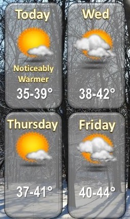
Today, expect mostly sunny skies with a high near 38, the weather service said. A southwest wind of 5 to 9 mph will become light in the afternoon.
Tonight, the low will be around 21 with partly cloudy skies and a south southwest wind of 3 to 6 mph, according to the weather service.
Wednesday will be warmer, with a high near 42 and sunny skies, the weather service said. A south wind of 8 mph will become west northwest in the afternoon.
Wednesday night, it will be partly cloudy with a low of 23, according to the weather service, and northwest wind of 6 to 8 mph.
Thursday, it will be sunny with a high of 41, the weather service said. A northwest wind of 5 to 7 mph will become southwest in the afternoon. Thursday night, the low will be around 25.
Friday, expect partly sunny skies and a high near 44, according to the weather service. Friday night, the low will be around 31.
Saturday, the high will be near 45 with mostly cloudy skies, the weather service said.
On Saturday night, Christmas Eve, there will be a 40 percent chance of rain, with a low around 41, according to the weather service.
Sunday, Christmas Day, the forecast is a 40 percent chance of showers, with a high near 57, and breezy, the weather service said.
Sunday night, there is a 60 percent chance of showers with a low of 27, according to the weather service.
Monday, it will be mostly sunny with a high near 37, the weather service said.