A little light freezing drizzle has now left the Kansas City area, and the rest of today is expected to be dry.
The next chance for widespread precipitation will be late Sunday night into Monday morning, when rain is expected, according to the National Weather Service.
The temperature was 24 with a wind chill of 14 at 8 a.m. Wednesday.
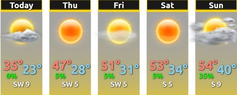
Today’s high will be near 35, the weather service said. Clouds will gradually clear after mid-morning. There will be a west southwest wind of 7 to 10 mph.
Tonight, it will be clear with a low of 22 and a west southwest wind of 3 to 6 mph, according to the weather service.
Thursday, it will be sunny with a high near 47 and a southwest wind of 3 to 7 mph, the weather service said.
Thursday night, it will be mostly clear with a low of 27 and a southwest wind of 3 to 5 mph, according to the weather service.
Friday, it will be sunny with a high near 51 and a west southwest wind of 3 to 6 mph, the weather service said.
Friday night, it will be mostly clear, with a low of 30, according to the weather service.
Saturday, it will be sunny with a high near 53, the weather service said.
Saturday night, it will be mostly clear with a low of 33, according to the weather service.
Sunday, it will be partly sunny with a high near 54, the weather service said.
Sunday night, it will be mostly cloudy, with a low of 44, according to the weather service.
Monday, it will be mostly cloudy, with a high near 56, the weather service said.
Monday night, it will be partly cloudy, with a low of 32, according to the weather service.
Tuesday, it will be sunny with a high near 50, the weather service said.