Today, temperatures may reach a high near 50, according to the National Weather Service forecast.
Freezing temperatures overnight could lead to some slick spots for motorists this morning, the weather service said.
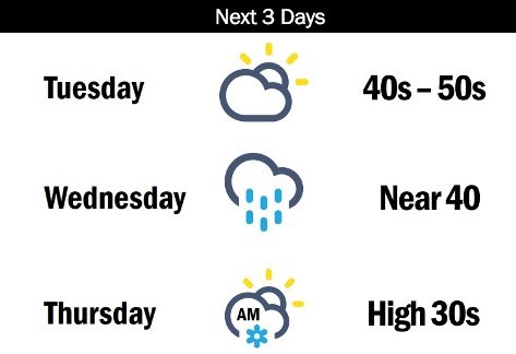
A new storm system will move into the area midweek, bringing a chance of rain on Wednesday and the possibility of a little snow late Wednesday night and early Thursday morning, according to the weather service.
Today, it will be mostly sunny, with a high near 50 and a light south wind becoming southeast 5 to 9 mph in the morning, the weather service said.
Tonight, it will be mostly cloudy, with a low of 33 and a southeast wind of 9 mph, according to the weather service.
Wednesday, there will be a 50 percent chance of rain, with a high near 42 and a southeast wind of 6 to 9 mph, the weather service said. New precipitation could be less than a tenth of an inch.
Wednesday night, there will be a 40 percent chance of rain before 2 a.m., then a chance of rain and snow, according to the weather service. The low will be around 32 with an east northeast wind of 5 to 7 mph. Between a tenth and quarter-inch of rain is possible.
Thursday, it will be mostly cloudy, with a high near 39 and an east northeast wind of 8 mph, the weather service said.
Thursday night, it will be mostly cloudy, with a low of 25, according to the weather service.
Friday, it will be partly sunny, with a high near 37, the weather service said.
Friday night, it will be mostly cloudy, with a low of 25, according to the weather service.
Saturday, it will be mostly cloudy, with a high near 37, the weather service said.
Saturday night, it will be mostly cloudy, with a low of 23, according to the weather service.
Sunday, it will be partly sunny, with a high near 36, the weather service said.
Sunday night, it will be mostly cloudy, with a low of 23, according to the weather service.
Monday, it will be mostly sunny, with a high near 40, the weather service said.