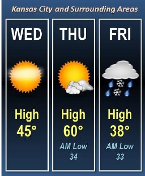
Today will be sunny with a high of about 45, and it will be the start of three days of changing weather, according to the National Weather Service forecast.
While temperatures will hit a peak in the 60s on Thursday, a cold front will follow, with a high of 39 and a chance of snow on Friday, the weather service said. Another chance of snow will be on Sunday.
Today’s forecast is sunny, with a high near 45 and a west northwest wind of 5 to 7 mph becoming south southwest in the afternoon, the weather service said.
Tonight, it will be partly cloudy with a low of 35 and a south wind of 7 to 9 mph, according to the weather service.
Thursday, it will be mostly sunny with a high near 62 and a south wind of 9 to 14 mph, gusting as high as 23 mph, the weather service said.
Thursday night, the low will be around 35 with a west northwest wind of 6 to 8 mph becoming north northeast after midnight.
Friday, there is a 70 percent chance of rain and snow between 8 a.m. and 10 a.m., then rain is likely, the weather service said. The high will be near 39 with a north northeast wind of 7 to 14 mph, gusting as high as 24 mph. A new snow accumulation of less than a half-inch is possible.
Friday night, there is a 70 percent chance of snow, mainly before 8 p.m., according to the weather service. The low will be around 19.
Saturday, the high will be near 38 with mostly sunny skies, the weather service said.
Saturday night, the low will be around 27 with partly cloudy skies, according to the weather service.
Sunday, there is a 50 percent chance of snow before noon, then a chance of rain and snow between noon and 1 p.m., then a chance of rain after 1 p.m., the weather service said. The high will be near 43.
Sunday night, there is a 30 percent chance of rain before 8 p.m., with a low around 32, according to the weather service.