It was a cool 47 degrees at 8 a.m. Thursday, with a high near 63 predicted today.
During the next few days, expect some storms and rain. While Thursday will be clear, Friday could have showers starting at 2 a.m. Rain and storms then are possible each day through Saturday.
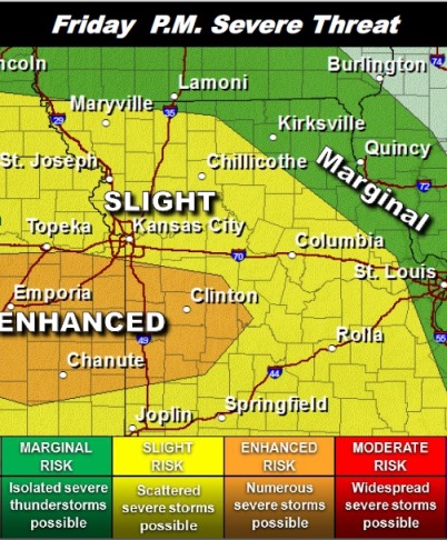
The National Weather Service said the risk for strong to severe thunderstorms is in the forecast for Friday afternoon through the evening.
Large hail will be the primary threat. There is a small threat for isolated tornadoes mainly within the “enhanced” outlook area, according to the weather service. Wyandotte County is north of that area.
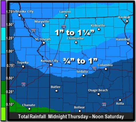
Rainfall in excess of 1 inch with local amounts up to 2 inches in stronger storms is possible, the weather service said.
A warm layer of air aloft known as a “cap” may be difficult to break through and delay the onset or greatly limit the amount of severe weather, according to the weather service.
The first wave of showers and thunderstorms is expected to arrive after midnight tonight, the weather service said. The rain will spread from west to east and exit in the afternoon. The rainfall tied to this first wave will average around a quarter of an inch, according to the weather service.
A second and potentially much stronger round of thunderstorms is expected to form over central Kansas and track northeast along a warm front Friday evening, according to the weather service.
In addition to the threat of severe thunderstorms locally heavy rainfall and minor flooding will define this period, the weather service said. An additional half-inch to 1 inch of rain is likely with local amounts up to 2 inches possible.
For more weather information, visit www.weather.gov.