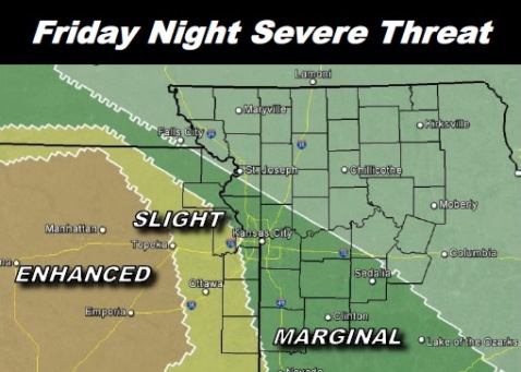
Isolated strong to severe thunderstorms are possible on Friday, according to the National Weather Service.
Rain was falling about 8 a.m. in parts of Wyandotte County. There is a chance of showers and possibly a thunderstorm between 9 a.m. and 11 a.m., the weather service said.
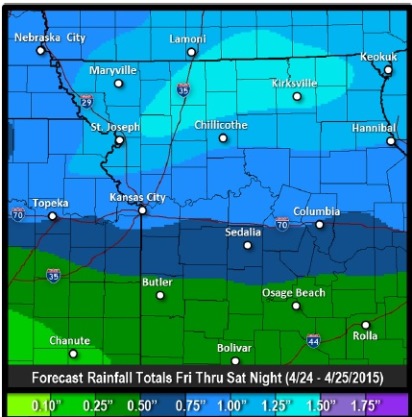
The chance of showers and thunderstorms continues after 11 a.m., the weather service said. The chance of precipitation is 60 percent, and a south-southeast wind from 10 to 15 mph is expected, with gusts as high as 22 mph. There could be a tenth to a quarter of an inch of rain possible.
Tonight, there is a 90 percent chance of showers and thunderstorms, mainly before 1 a.m., the weather service said. A south southeast wind of 13 to 15 mph may gust as high as 21 mph. There could be between a half to three-quarters of an inch of rain.
Wyandotte County is in the “marginal” risk category for severe storms, according to a weather service graphic, which means isolated severe thunderstorms are possible.
The weather service anticipates the strongest storms will be west of a line from Falls City, Neb., to Sedalia, Mo., which includes Wyandotte County. Some isolated flooding may be possible along and north of Highway 36, around the St. Joseph, Mo., area, because of heavy rain, according to the weather service.
On Saturday, expect showers and thunderstorms before 1 p.m. The chance of rain is 30 percent, and it will be windy, with a south southwest wind of 13 to 18 mph becoming northwest in the afternoon, and winds gusting as high as 28 mph.
To keep up to date on the weather today, visit www.weather.gov.