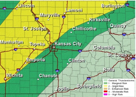
Storms may be possible Wednesday and this weekend, according to the weather service, as a strong cold front moves in. On Wednesday night, there is a possibility for severe storms.
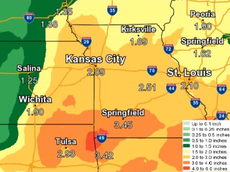
Heavy rain is possible over the weekend, as a strong storm system moves in late Friday afternoon through Saturday, the weather service said.
Today, the forecast calls for mostly cloudy skies with a high near 78, and a south wind of 8 to 13 mph, gusting as high as 20 mph, the weather service said.
Tonight, it will be mostly cloudy with a low of 62 and a south wind of 8 to 10 mph, according to the weather service. There may be storms to the north of the Kansas City area.
Wednesday, it will be partly sunny with a high near 83, the weather service said. A south wind of 7 to 12 mph will increase to 15 to 20 mph in the afternoon, gusting as high as 32 mph.
Wednesday night, there is a 40 percent chance of showers and storms, with a low of 54, according to the weather service. A south southwest wind will be 9 to 16 mph, becoming west northwest after midnight. Winds may gust as high as 28 mph. Between a tenth and a quarter-inch of rain is possible.
Thursday, there is a 20 percent chance of showers before 1 p.m., with a high near 65, the weather service said. There will be a north northwest wind of 10 mph.
Thursday night, it will be partly cloudy with a low of 47, according to the weather service.
Friday, there is a 50 percent chance of showers with a high near 59, the weather service said.
Friday night, there is an 80 percent chance of showers with a low of 47, according to the weather service.
Saturday, there is an 80 percent chance of rain with a high of 54, the weather service said.
Saturday night, expect a 40 percent chance of rain before 1 a.m. with a low of 43, according to the weather service.
Sunday, skies will be sunny with a high near 65, the weather service said.