Thunderstorms are possible today in Wyandotte County and the region, according to the National Weather Service.
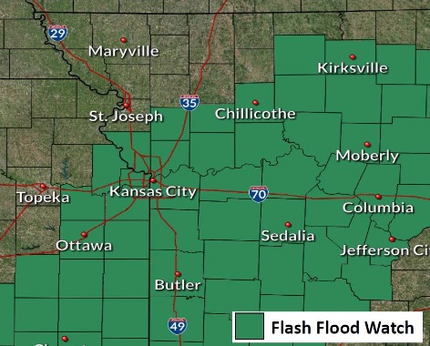
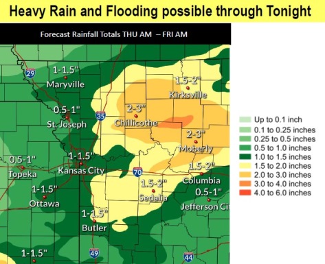
A flash flood watch has been issued for Wyandotte County from 7 p.m. Thursday through 7 a.m. Friday, according to the weather service. Heavy rain is possible, which could result in flash flooding and river flooding in places. One inch of rain is possible today through Friday morning in Wyandotte County, according to the forecast.
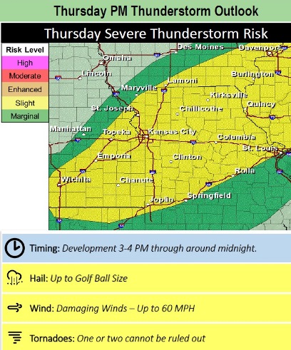
Strong to severe storms are expected to redevelop this afternoon and this evening, with hail and damaging winds the primary threat, the weather service said. A tornado cannot be ruled out.
The storm could develop between 3 p.m. and 4 p.m. Thursday, and the hazards include hail up to golf-ball size, damaging winds up to 60 mph, and tornadoes, according to the weather service.
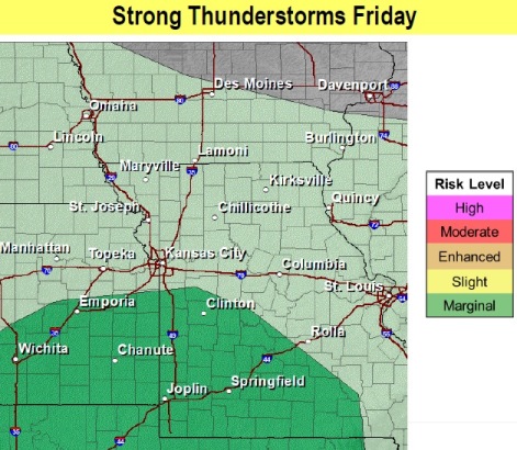
On Friday, strong thunderstorms are possible south of the Kansas City metropolitan area, according to the weather service.
Today, there is a 60 percent chance of showers and thunderstorms, then rain and thunderstorms are likely after 3 p.m., the weather service said. The high will be near 77 with a south wind of 8 to 14 mph, gusting as high as 25 mph. Between a tenth and quarter-inch of rain are possible.
Tonight, there is an 80 percent chance of rain and thunderstorms, mainly before 2 a.m., according to the weather service. The low will be around 61 with a south wind of 6 to 14 mph, becoming north after midnight. Winds may gust as high as 23 mph. Between a half and three-quarters of an inch of rain is possible.
Friday, there is a 50 percent chance of rain and thunderstorms, with a high near 74, the weather service said, and an east northeast wind of 7 to 9 mph. Less than a tenth of an inch of rain is expected.
Friday night, there is an 80 percent chance of rain and thunderstorms, then rain and possibly a thunderstorm after 8 p.m., according to the weather service. The low will be around 64 with an east wind of 3 to 8 mph. Between a quarter and half-inch of rain is possible.
Saturday, there is a 90 percent chance of rain and possibly a thunderstorm before 2 p.m., then rain and thunderstorms after 2 p.m., the weather service said. A light and variable wind will become southeast around 6 mph in the morning. New rainfall amounts between a half and three-quarters of an inch are possible.
Saturday night, there is a 90 percent chance of rain and thunderstorms, mainly before 8 p.m., according to the weather service. The low will be around 57. Between a tenth and quarter-inch of rain is expected.
Sunday, it will be mostly sunny, with a high near 72, the weather service said.
Sunday night, it will be mostly clear with a low of 51, according to the weather service.
Monday, it will be sunny with a high near 71, the weather service said.
Monday night, it will be mostly clear, with a low of 52, according to the weather service.
Tuesday, it will be sunny, with a high near 78, the weather service said.
Tuesday night, it will be mostly clear, with a low of 57, according to the weather service.
Wednesday, it will be sunny, with a high near 81, the weather service said.
For more weather information, visit www.weather.gov.