Scattered thunderstorms are possible across much of the area today, according to the National Weather Service.
Isolated strong to severe storms are possible with large hail and damaging winds the primary threats, the weather service said.
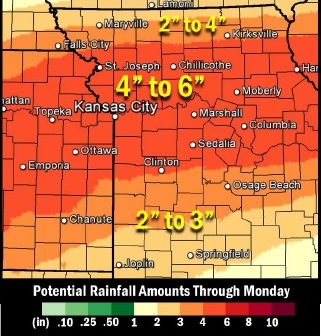
Numerous rounds of thunderstorms are expected across much of the region Friday night through Sunday night, according to the weather service. These thunderstorms will likely produce several rounds of heavy rain, with the potential for one to three inches of rain Saturday and Saturday night, and another one to three inches of rain on Sunday and Sunday night. Total rainfall amounts could be in the four to six-inch range for some locations.
Excessive rainfall this weekend could lead to numerous areas of flash flooding, including areas that don’t typically flood, the weather service said.
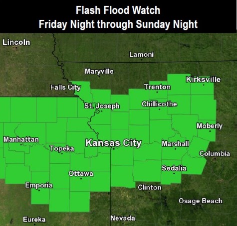
Widespread river flooding is also possible, according to the weather service. A flash flood watch is in effect for much of northern Kansas and western and central Missouri Friday night through Sunday night.
This flash flood watch area includes Wyandotte County, and it is in effect from 7 p.m. July 1 until 4 a.m. July 4, the weather service said.
Residents are advised to monitor weather forecasts and be prepared to take action should flash flood warnings be issued.
Today, expect a high of 89 with a 40 percent chance of showers and thunderstorms, mainly after 10 a.m., the weather service said.
Tonight, there is a 40 percent chance of showers and thunderstorms, with a low of 68, and a north wind of 5 mph becoming east northeast after midnight, according to the weather service.
Friday, the high will be 82 with a 30 percent chance of showers and thunderstorms, the weather service said. There will be an east wind of 6 to 9 mph.
Friday night, the low will be around 64 with a 70 percent chance of showers and thunderstorms, according to the weather service. Between three-quarters and one inch of rain is possible.
Saturday, there is an 80 percent chance of showers and thunderstorms with a high of 77, the weather service said. There will be an east wind of 8 to 11 mph. New rainfall amounts of between 1 and 2 inches are possible.
Saturday night, there is an 80 percent chance of showers and thunderstorms, with a low of 65, according to the weather service. Between 1 and 2 inches of rain are possible.
Sunday, there is a 70 percent chance of showers and thunderstorms, with a high near 79, the weather service said.
Sunday night, the chance of precipitation is 40 percent, with a low of 67, the weather service said.
On Monday, Independence Day, there is a 30 percent chance of showers and thunderstorms, with a high near 82, according to the weather service.
For more weather information, visit www.weather.gov or listen to a weather radio.