Thunderstorms and heavy rain are in the forecast this afternoon and tonight in Wyandotte County, according to the National Weather Service.
The atmosphere this morning may take a break from showers, but additional showers and thunderstorms are expected this afternoon, the weather service said. A few of the storms could be strong along the state line, producing small hail, gusty winds and locally heavy rainfall.
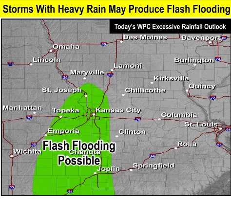
Severe weather is not anticipated, but storms will be capable of heavy rainfall that could produce flash flooding, the weather service said.
Wyandotte County may receive between a quarter-inch and half-inch of rain during the daytime and from three-quarters to one inch of rain tonight, according to the weather service.
Warmer conditions are expected this weekend into next week, the weather service said. Additional disturbances may try to track through the region, leading to more showers and thunderstorms.
More rain is possible on Friday, Saturday, Sunday, Monday, Tuesday and Wednesday, the forecast stated. Additional rain will cause continued rises on area streams, creeks and rivers, the weather service said.
The NOAA and NWS hydrology charts for rivers in Wyandotte County show that the rivers are well below flood stage or action stage.
Stranger Creek at Easton in Leavenworth County is under a flood warning, according to the weather service.
Today, there is an 80 percent chance of showers and thunderstorms, then more showers and possibly a thunderstorm after 4 p.m., the weather service said. The high will be near 75, with a south wind of 5 to 10 mph, gusting as high as 18 mph. Between a quarter and half-inch of rain is possible.
Tonight, there is a 60 percent chance of showers and possibly a thunderstorm before 7 p.m., then a chance of showers and thunderstorms mainly between 7 p.m. and 1 a.m., according to the weather service. Some of the storms may produce heavy rainfall. The low will be around 66 with a south southeast wind of 9 to 11 mph, gusting as high as 22 mph. Between three-quarters and one inch of rain is possible.
Friday, there is a 40 percent chance of showers and thunderstorms, with a high near 80, the weather service said. A south wind of 9 to 14 mph will gust as high as 23 mph. Less than a tenth of an inch of rain is possible.
Friday night, it will be mostly cloudy, with a low around 66 and a south wind of 7 to 10 mph, according to the weather service.
Saturday, there is a 40 percent chance of showers and thunderstorms, with a high near 80, the weather service said. A south wind of 6 to 11 mph will gust as high as 20 mph. Less than a tenth of an inch of rain is expected.
Saturday night, it will be mostly cloudy, with a low of 65, according to the weather service.
Sunday, there is a 30 percent chance of showers and thunderstorms after 1 p.m., with a high near 82, the weather service said.
Sunday night, it will be partly cloudy, with a low of 66, according to the weather service.
Monday, there is a 40 percent chance of showers and thunderstorms after 1 p.m., the weather service said. The high will be near 82.
Monday night, there is a 40 percent chance of showers and thunderstorms after 1 a.m., according to the weather service. The low will be around 66.
Tuesday, there is a 70 percent chance of showers and thunderstorms, with a high near 81, the weather service said.
Tuesday night, there is a 70 percent chance of showers and thunderstorms, with a low around 64, according to the weather service.
Wednesday, there is a 60 percent chance of showers and thunderstorms, the weather service said. The high will be near 80.