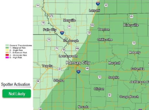
A few strong thunderstorms are possible this afternoon, mainly east of I-35, according to the National Weather Service.
Gusty winds and localized flash flooding are possible with the strongest, most persistent storms, the weather service said.
Thunderstorm chances persist into Wednesday but they will eventually shift southeast of the area by the afternoon to evening hours, according to the weather service.
Today’s high may be near 78, the weather service said, with a south southeast wind of 3 to 6 mph. There is a 60 percent chance of rain. In the morning, showers are possible, then thunderstorms are likely after 1 p.m. Expect between a tenth and a quarter-inch of rain.
Tonight, there is a 70 percent chance of precipitation, with showers and storms likely before 1 a.m. The low will be around 61, with a west southwest wind of 5 mph becoming calm in the evening. New rainfall amounts between a quarter and half-inch are possible.
Wednesday, there is a 30 percent chance of showers and thunderstorms, mainly before 1 p.m., the weather service said. The high will be near 78, with a north wind of 3 to 7 mph. New rainfall amounts are less than a tenth of an inch, except higher amounts possible in thunderstorms.
There’s no more rain in this week’s forecast after Wednesday, according to the weather service.
Wednesday night, the low will be around 57, with a north wind of 3 to 6 mph, according to the weather service.
Thursday, the forecast is sunny with a high near 79, the weather service said. There will be an east northeast wind of 3 to 6 mph. Friday and Saturday’s highs will be near 81.